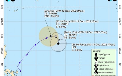
(Image courtesy of PAGASA)
MANILA – Tropical Storm (TS) Rosal slightly weakened as it continued to move away from the country, the weather bureau said Monday afternoon.
Rosal now has maximum sustained winds of 75 kph near the center, and gustiness of up to 90 kph. It was last seen 880 km. east of extreme Northern Luzon, moving east northeastward at 15 kph.
Rosal is forecast to rapidly weaken, and may become a remnant low either Tuesday or Wednesday, the Philippine Atmospheric, Geophysical and Astronomical Services Administration (PAGASA) said.
Rosal is less likely to directly bring heavy rains throughout the forecast period.
The northeast monsoon, however, will continue to cause light rains over Batanes, Cagayan including Babuyan Islands and Apayao.
Metro Manila and the rest of the country could expect isolated rain showers caused by localized thunderstorms.
Meanwhile, PAGASA said in the next 24 hours, the surge of the northeast monsoon partly enhanced by Rosal may bring occasional gusts reaching gale-force over Batanes, and strong breeze to near-gale strength over Babuyan Islands, and the coastal and upland areas of Ilocos Norte, northern and eastern Cagayan and eastern Isabela.
Rough to very rough seas still prevail over the seaboards of Batanes, Ilocos Norte, Ilocos Sur, La Union, Pangasinan, Cagayan including Babuyan Islands and Isabela.
PAGASA advised fishing boats and other small seacraft not to venture into the sea and larger sea vessels are alerted against big waves.
Moderate to strong winds and moderate to rough seas are forecast over Luzon, while light to moderate moderate winds and slight to moderate seas will continue to prevail over the Visayas and Mindanao. (PNA)
