(Image courtesy of PAGASA)
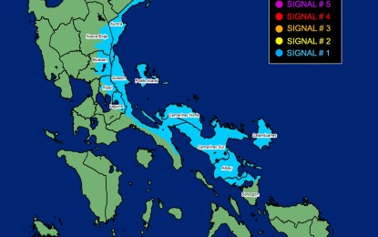
MANILA – Signal No. 1 remains hoisted over some areas in Luzon as Tropical Depression (TD) Amang makes landfall over Lagonoy, Camarines Sur Wednesday afternoon, the weather bureau said.
Amang is slowly moving northwestward, packing maximum sustained winds of 45 kph near the center and gustiness of up to 55 kph.
Signal No. 1 remains hoisted over Catanduanes, Sorsogon (City of Sorsogon, Pilar, Castilla, Donsol, Prieto Diaz), Albay, Camarines Sur, Camarines Norte, Laguna (Cavinti, Lumban, Kalayaan, Paete, Pakil, Pangil, Siniloan, Famy, Santa Maria, Mabitac), Aurora, Quezon (Buenavista, Calauag, Infanta, Lopez, Guinayangan, Plaridel, Quezon, Alabat, Sampaloc, Mauban, General Nakar, Perez, Gumaca, Atimonan, Real, Tagkawayan, San Narciso) including Pollilo Islands, Rizal (Tanay, Pililla, Rodriguez, Baras, City of Antipolo), Bulacan (Norzagaray, Doña Remedios Trinidad) and Nueva Ecija (Gabaldon, Bongabon, Laur, General Tinio)
These areas may experience strong breeze to near gale strength winds which may cause minimal to minor impacts to life and property, the Philippine Atmospheric, Geophysical and Astronomical Services Administration (PAGASA) said.
TD Amang may bring rains with gusty winds over Bicol Region and the provinces of Laguna, Quezon, Rizal, Bulacan, Nueva Ecija and Aurora.
It could also cause scattered rain showers and thunderstorms over Metro Manila, Cagayan Valley, the rest of Central Luzon, the rest of Calabarzon, Oriental Mindoro, Occidental Mindoro, Marinduque, Romblon, Aklan, Capiz and Antique.
PAGASA warned residents of these areas against possible flooding or landslides due to moderate to heavy with at times intense rains.
Moderate to rough seas may be experienced over the eastern and southern seaboards of Southern Luzon and the eastern seaboard of Central Luzon. PAGASA advised mariners of small seacraft to take precautionary measures when venturing to the sea and to avoid navigating in these conditions if possible.
Meanwhile, in the next 12 hours, the TD is expected to pass over the eastern localities in Camarines Sur, Lamon Bay and Quezon. It is also forecast to weaken into a low pressure area by Thursday. (PNA)
