(File photo)
MANILA – Mawar has reintensified into a super typhoon as it continues to move closer to the Philippine Area of Responsibility (PAR), the weather bureau said Thursday.
In its 5 a.m. weather bulletin, the Philippine Atmospheric, Geophysical and Astronomical Services Administration (PAGASA) said Mawar was last tracked 2,150 km east of southeastern Luzon, packing maximum winds of up to 185 km per hour near the center and gustiness of up to 230 kph.
Moving west northwest at 15 kph, Mawar may enter PAR by Friday evening or Saturday morning and will be given the local name Betty.
The typhoon's rain bands are expected to bring heavy rains over Cagayan Valley between Sunday and Tuesday next week, PAGASA added. It may also enhance the southwest monsoon, bringing rains over the western parts of Luzon and Visayas beginning Sunday or Monday.
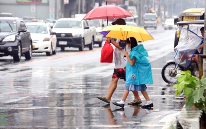
Meanwhile, many areas in the country will continue to experience rains due to the southwesterly windflow and localized thunderstorms on Thursday.
Scattered rain showers and thunderstorms will prevail over Occidental Mindoro, Palawan, Western Visayas, Northern Mindanao, Soccsksargen, Zamboanga Peninsula and BARMM due to the southwesterly windflow.
Flash floods or landslides are possible due to moderate to at times heavy rains, the Philippine Atmospheric, Geophysical and Astronomical Services Administration (PAGASA) said.
PAGASA weather specialist Benison Estareja said more areas will experience rains in the afternoon through evening because of the southwesterly windflow and localized thunderstorms.
Isolated rain showers or thunderstorms are forecast over Metro Manila and the rest of the country. Severe thunderstorms may cause flash floods or landslides.
Moderate winds and moderate seas will prevail over the northern and eastern sections of Luzon.
Elsewhere, winds will be light to moderate with slight to moderate seas.
Preparations
The National Disaster Risk Reduction and Management Council (NDRRMC) has alerted its regional counterparts, local government units (LGUs), and the public to take the necessary precautions ahead of the tropical cyclone.
Government agencies are now implementing measures based on emergency preparedness and response protocols of NDRRMC which include dissemination of warnings, preparation of relief assistance for distribution, and rescue teams for deployment, among others.
According to the Department of Social Welfare and Development, a total of 797,051 family food packs (FFPs) worth PHP565.78 million have been stockpiled in its regional offices.
There are also 110,667 FFPs available in Disaster Response Centers, with the breakdown as follows: 101,525 FFPS at the National Resource Operations Center (NROC) in Pasay City and 9,142 FFPs at the Visayas Disaster Resource Center.
Meanwhile, the Department of the Interior and Local Government (DILG), meanwhile, directed all its regional directors to coordinate with their respective regional disaster risk reduction and management councils (RDDRMCs) and to remind all LGUs to prepare for the coming storm.
The DILG also added that all LGUs, especially those in areas with recent experience of extended or prolonged rain occurrences and/or landslides or floods, shall continue to monitor all PAGASA weather advisories and typhoon bulletins.
The NDRRMC will continue its monitoring of the situation and implement all necessary preparations for the weather disturbance.
The NDRRMC called on the public to prepare for the storm by monitoring the advisories and heeding the warnings issued by relevant agencies. (with Priam Nepomuceno/PNA)
