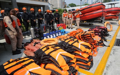
FRONTLINERS. The Metropolitan Manila Development Authority and the Metro Manila Disaster Risk Reduction and Management Council prepare rescue and response equipment at the MMDA compound in Pasig City on Thursday (May 25, 2023) in preparation for Super Typhoon Mawar, or Betty once it enters the Philippine Area of Responsibility by Friday night or Saturday morning. Assets ready for dispatch are rubber boats, aluminum boats, fiberglass boats, life vests, rescue vehicles, and military trucks. (PNA photo by Joan Bondoc)
MANILA – Super Typhoon Mawar has intensified over the Philippine Sea as it nears the Philippine Area of Responsibility (PAR), bringing strong to typhoon-force winds that extend up to 550 km. from the center.
In its weather advisory Friday, the Philippine Atmospheric, Geophysical and Astronomical Services Administration said the eye of Mawar, last observed at 3 a.m., was 1,740 km. east of southeastern Luzon, outside the Philippine Area of Responsibility (PAR).
It packs maximum sustained winds of 215 kph near the center and gusts of 265 kph, moving west at 20 kph.
Mawar, to be given the local name Betty once it enters PAR, is expected tonight or Saturday, according to the weather bureau.
Although Mawar could slightly weaken by Saturday, it is still expected to remain a super typhoon until early Monday. It is forecast to reach its peak intensity within 24 to 36 hours.
The tropical cyclone may bring heavy rains, which may trigger flooding or rain-induced landslides, over Northern Luzon beginning late Sunday or Monday.
Strong to storm-force conditions may be experienced over extreme Northern Luzon, while strong to gale-force conditions are possible over the northern and eastern portions of Northern Luzon mainland, PAGASA said.
The bureau said the southwesterly wind flow and localized thunderstorms will continue to dampen a huge part of the country.
Scattered rain showers and thunderstorms still prevail over the Zamboanga Peninsula, Northern Mindanao, Soccsksargen, and BARMM due to the southwesterly wind flow.
Flash floods or landslides are possible in those areas due to moderate to at times heavy rains, PAGASA said.
Isolated rain showers caused by the southwesterly wind flow and localized thunderstorms will still be experienced over Metro Manila and the rest of the country.
PAGASA warned that flash floods or landslides are possible during severe thunderstorms.
Moderate winds and moderate seas will prevail over the eastern section of Luzon and the Visayas.
Elsewhere, winds will be light to moderate with slight to moderate seas. (PNA)
