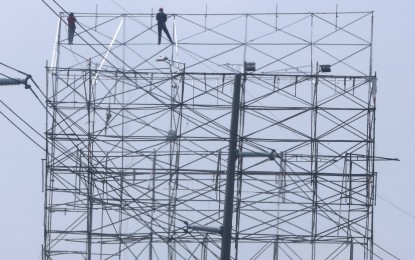
READY FOR 'BETTY'. Workers fold a giant tarpaulin along North Luzon Expressway in Marilao, Bulacan on Friday (May 26, 2023) in preparation for Super Typhoon Mawar. The tropical cyclone that will be named Betty once inside the Philippine Area of Responsibility by Friday night or early Saturday may weaken into a typhoon but is expected to still bring rains and strong winds. (PNA photo by Joey O. Razon)
MANILA – Super Typhoon Mawar may downgrade into typhoon category as it approaches Batanes but could still bring strong winds, an official of the weather bureau said Friday.
"It may weaken into a typhoon before it goes near Batanes, but a typhoon is still strong. Don't think that it's weak as this could trigger strong winds that could hit trees and roofs," Philippine Atmospheric, Geophysical and Astronomical Services Administration (PAGASA) Deputy Administrator Esperana Cayanan said in a press conference.
Tropical cyclone wind signal (TCWS) No. 3 could be hoisted over Batanes, she added.
The latest update from the weather bureau said Mawar was last tracked 1,705 km. east of southeastern Luzon, packing maximum sustained winds of 215 kph, and gusts of up to 20 kph.
PAGASA forecast Mawar to reach its peak intensity of 220 kph maximum sustained winds within 24 hours.
The super typhoon is expected to enter the Philippine Area of Responsibility (PAR) either Friday night or early Saturday and will be named "Betty".
It is forecast to be 250 km of Batanes and Babuyan Islands by next week.
PAGASA weather specialist Ana Clauren said the hoisting of TCWS may begin Saturday in anticipation of severe winds.
Strong to storm-force conditions may be experienced over extreme Northern Luzon, while strong to gale-force conditions are possible in the northern and eastern portions of the mainland of Northern Luzon.
Clauren said Mawar may enhance the southwest monsoon that could trigger rains over the western portion of Central and Southern Luzon and the Visayas beginning Sunday or Monday.
She urged the public to coordinate precautionary measures with the local government because the moderate to heavy rains may trigger flash floods or landslides.
Esperana, on the other hand, said rains caused by localized thunderstorms may still be experienced.
"We've been having thunderstorms for the past days. There's a high probability that thunderstorms will continue, especially in the afternoon," she said.
Sea-ready
In an update on Friday, the Philippine Ports Authority (PPA) said ports have secured objects that may be affected by strong winds and installed precautionary signs inside passenger terminal buildings while constantly posting updates on suspended trips in coordination with the Philippine Coast Guard (PCG).
Hot meals are also on standby for possible stranded passengers.
“Inaabisuhan ng PPA na manatiling naka-antabay sa anunsyo ng pamahalaan at ng mga pupuntahang lugar para maiwasan ang abala (The PPA advises to remain vigilant for announcements from government authorities and the local government at their destination to avoid hassle),” read an advisory.
The Maritime Industry Authority likewise released an advisory for the “strict adherence to safety measures and precautionary protocols” to ship and boat owners and called for the activation of emergency procedures.
To prepare for rescue scenarios, the PCG has deployable response groups in areas that could be affected by the tropical cyclone and maintains staff in all ports. (With a report from Raymond dela Cruz/PNA)
