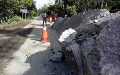
ROAD CRACKS. Growing cracks at a road section in Sogod, Southern Leyte prompted the DPWH to close the highway that links to Mindanao since March 14. (Photo courtesy of DPWH Southern Leyte)
TACLOBAN CITY -- The road that links Leyte Island to Mindanao remained closed two weeks after the Department of Public Works and Highways (DPWH) noticed cracks, indicating a potential major landslide.
In a statement issued Tuesday, DPWH Southern Leyte field office chief Ma. Margarita Junia said they are still unsure when to re-open the road in Pancho Villa village in Sogod town with the ongoing intensive soil exploration and anti-landslide measures.
"One thing is for sure, the road is not safe. There is an active ground movement in the slope along the highway that might collapse anytime," Junia said.
The road closure has affected Mindanao-bound motorists, who prefer to take the landslide-prone road to get to Benit port in San Ricardo, Southern Leyte.
Benit port is considered as the region’s gateway to Mindanao.
Since March 14, the 200-meter road section that forms part of the major highway that connects Luzon, Samar, Leyte and Mindanao Islands, has been closed to all types of vehicles.
The road section is just six kilometers away from Agas-Agas Bridge, the country’s tallest. The road stretch has been tagged as highly susceptible to landslides.
Motorist bound for Benit port are advised to take the Tacloban-Mahaplag-Baybay-Bato-Bontoc-Liloan-San Ricardo route and vice versa or Tacloban-Abuyog-Silago-St. Bernard-Jct. Himay-angan-Daang Maharlika-Liloan-San Ricardo route and vice versa.
From Tacloban to Pacific towns, motorists can take the Tacloban-Abuyog-Silago-St. Bernard route and vice versa orTacloban-Mahaplag-Baybay-Bato-Bontoc-Sogod-Jct. Himay-angan-St. Bernard-Silago-Abuyog road route and vice versa.
Preliminary findings of the Mines and Geosciences Bureau confirmed the presence of active ground movements in tension cracks, ruptured surface, and vertical displacements in the road section.
The assessment within the 200-meter stretch of the road also showed that there is an increase in water discharge and water saturation from springs nearby, which caused changes in groundwater level and increase of water pressure.
The DPWH Southern Leyte district office initiated a soil study to determine the properties of the subsurface soil and identify proper measures to prevent major erosions.
The exploration will dig up to 20 meters or more to get soil samples, and identify the most stable soil level, which is highly necessary in determining the most efficient erosion prevention technology applicable in the area. (PNA)
