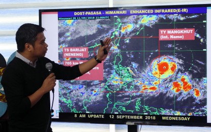
TYPHOON 'OMPONG'. PAGASA senior weather specialist Chris Perez points to the satellite image of the track of typhoon "Mangkhut" ("Ompong") during a press conference at the weather bureau's main office in Quezon City on Wednesday morning. "Ompong" is expected to bring heavy to intense rains, strong winds, and storm surges in Luzon as it enters the Philippine Area of Responsibility Wednesday afternoon. (PNA photo by Joey O. Razon)
(Updated) MANILA -- Heavy to intense rains, strong winds and storm surges threaten Luzon as Typhoon Ompong (international name "Mangkhut") entered the Philippine Area of Responsibility Wednesday afternoon.
In its latest update, the Philippine Atmospheric, Geophysical and Astronomical Services Administration (PAGASA) said "Ompong" may reach a peak intensity of 220 km. per hour (kph) near the center and gustiness of up to 270 kph on Thursday (September 13).
In a press conference Wednesday, PAGASA Administrator Dr. Vicente Malano said the typhoon is expected to make landfall in Cagayan province on Saturday and warned residents near coastal areas to evacuate early as storm surges are expected to reach as high as six meters.
"Ompong" could still not be categorized as a super typhoon but has the potential to become one. The super typhoon category is at 225 kph, Malano said.
He said very strong winds, storm surges over coastal areas and heavy to intense rains are expected in Cagayan and Isabela and the rest of northern Luzon.
"Yung habagat plus ulan na galing sa bagyo, pwede siyang tumaas, pwedeng abutin si ‘Ondoy’ o lagpasan si ‘Ondoy’. 'Yung hangin nito malakas din, hindi lang 'yung baha ang ating tignan kasi pwede din siya mag-storm surge once it makes landfall sa Cagayan (The southwest monsoon plus rains brought by the typhoon could reach or even surpass ‘Ondoy’ levels. ‘Ompong's’ winds are strong and so we are not just looking at the possible flooding but also storm surges once it makes landfall in Cagayan)," he said.
He also belied information circulating on social media that the typhoon could bring storm surges as high as 15 meters, saying there is no history of storm surges of that magnitude. During the onslaught of Super Typhoon Yolanda (international name Haiyan) in November 2013, the recorded storm surge was 7 to 8 meters, he said.
"Hindi po natin tinitignan na magiging ganun kataas tulad ng lumalabas sa social media (We do not see it getting that high as what is being circulated in social media)," he said.
PAGASA weather forecaster Rene Paciente said the typhoon's peripheral effect would be felt in Catanduanes and several provinces in the eastern section of the country on Thursday.
The typhoon also enhances the southwest monsoon or habagat, which would bring occasional moderate to heavy rains on Wednesday in the Zamboanga peninsula, northern Mindanao and the provinces of Siquijor, Surigao del Norte, Agusan del Norte, Dinagat Island and Lanao del Sur.
Meanwhile, PAGASA is also monitoring a low-pressure area spotted 4,150 km. east of Mindanao.
Earlier, the National Disaster Risk Reduction and Management Council said its preparations for the onslaught of "Ompong" are the same as those implemented for "Yolanda". (PNA)
