(Image grabbed from PAGASA's Facebook page)
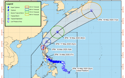
MANILA -- Severe Tropical Storm (STS) "Ambo" slightly weakened, and may make landfall over Real or Infanta, Quezon between 5 p.m. to 7 p.m. Friday, the state weather bureau said on Friday.
In its 5 p.m. bulletin, the Philippine Atmospheric, Geophysical and Astronomical Services Administration (PAGASA) said Ambo was last tracked 40 kilometers south of Infanta, Quezon, moving northwestward at 20 kph.
It packs maximum sustained winds of up to 100 kph near the center, and gustiness of up to 140 kph.
On Friday night, moderate to heavy with at times intense rains may be experienced over Quezon, Marinduque, Aurora, Laguna, Batangas, Rizal, Metro Manila, Bulacan, Pampanga, Nueva Ecija, Nueva Vizcaya, and Quirino.
Tropical cyclone wind signal (TCWS) no. 2 is hoisted over Ilocos Norte, Ilocos Sur, La Union, Apayao, Abra, Kalinga, Mountain Province, Ifugao, Benguet, the eastern portion of Pangasinan (San Nicolas, Natividad, San Quintin, Umingan, Balungao, Sta. Maria, Tayug, Asingan, San Manuel, Binalonan, Laoac, Urdaneta, Villasis, Rosales, Sto. Tomas, Alcala, Bautista, Bayambang, Urbiztondo, Basista, Malasiqui, Sta. Barbara, Manaoag, Mapandan, San Jacinto, San Fabian, Pozorrubio, Sison, Mangaldan, Dagupan, Calasiao, Binmaley, Lingayen, Bugallon, Aguilar, San Carlos, Mangatarem), Tarlac, Pampanga, Metro Manila, Bulacan, Laguna, Cavite, Batangas, Rizal, Marinduque, the northern portion of Quezon (General Nakar, Infanta, Real, Mauban, Sampaloc. Lucban, Tayabas, Sariaya, Candelaria, Dolores, Tiaong, San Antonio, Lucena, Pagbilao, Atimonan, Padre Burgos, Agdangan, Plaridel, Unisan, Gumaca, Pitogo, Macallelon, General Luna, Catanauan, Lopez, Buenavista, Guinayangan, Calauag, Tagkayawan, Perez, Alabat, Quezon), Polillo Islands, the western portion of Camarines Norte (Santa Elena, Capalonga), Nueva Ecija, Nueva Vizcaya, Aurora, Quirino, and the western portion of Isabela (Quezon, Mallig, Roxas, Quirino, San Manuel, Burgos, Gamu, Reina Mercedes, Aurora, Luna Cabanatuan, Naguilian, Benito Soliven, Cauayan, San Guillermo, Dinapugue, San Mateo, Alicia, Angadanan, Ramon, San Isidro, Echague, Jones, San Agustin, Santiago, Cordon).
These areas may have strong to damaging gale storm-force winds during the passage of Ambo.
TCWS no. 1 is raised over Cagayan including Babuyan Islands, Batanes, Zambales, Bataan, the rest of Pangasinan, the rest of Isabela, the rest of Quezon, the rest of Camarines Norte, the western portion of Camarines Sur (Del Gallego, Ragay, Lupi, Sipocot, Libmanan, Cabusao), and the northeastern portion of Oriental Mindoro (Puerto Galera, San Teodoro, Baco, Calapan, Naujan, Victoria, Socorro, Pola).
These areas may experience strong to gale-force winds during Ambo’s passage.
PAGASA warned that sea travel is risky for all types of seacraft over the seaboards of areas under TCWS.
Meanwhile, earlier in the Laging Handa public briefing, Department of Science and Technology Undersecretary Renato Solidum Jr. said PAGASA spotted a low-pressure area (LPA) outside the Philippine Area of Responsibility (PAR).
"The LPA was spotted 2,400 kilometers east of Mindanao. PAGASA will monitor this after (Ambo) exits PAR. The LPA is still far, but we have to prepare for it," Solidum said.
Ambo is expected to exit PAR by Monday, he added. (PNA)
