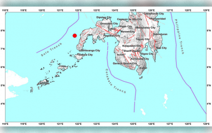
A map provided by the Philippine Institute of Volcanology and Seismology shows the location of the magnitude 4.6 earthquake that shook parts of Zamboanga Peninsula early Monday morning (June 15).
ZAMBOANGA CITY--An earthquake of magnitude 4.6 shook parts of Zamboanga Peninsula early Monday morning, the Philippine Institute of Volcanology and Seismology (Phivolcs) said.
Engr. Allan Rommel Labayog, Phivolcs-Zamboanga science research analyst, said the epicenter of the earthquake is 35 kilometers northwest of Siocon, Zamboanga del Norte.
The source of the earthquake, which took place around 6:29 a.m. Monday, was of tectonic origin, he said, adding that intensity four was felt in this city.
Labayog said intensity four earthquake is moderately strong and the closest source is the Sulu trench, one of the two major fault zones; the other is the Cotabato trench.
However, he said Phivolcs didn't expect any possible damage, including aftershocks. (PNA)
