(Image grabbed from PAGASA's website)
MANILA – Parts of the country will continue to experience rains due to the northeasterly surface wind flow and the trough of Typhoon "Rolly" that has intensified further, the weather bureau said in its 5 p.m. Friday bulletin.
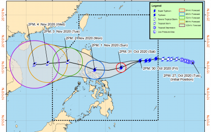
“Rolly” now packs maximum sustained winds of 185 kph near the center and gustiness of up to 230 kph.
It was last seen at 980 km. east of Casiguran, Aurora, moving westward at 20 kph.
Light to moderate with at times heavy rains will be experienced over the regions of Bicol, Eastern and Central Visayas, Caraga, Northern Mindanao, and the Zamboanga Peninsula, and the provinces of Batanes, Cagayan, and Isabela.
The Philippine Atmospheric, Geophysical and Astronomical Services Administration (PAGASA) maintained that “Rolly” is likely to make landfall over the Aurora-Quezon area on Sunday or Monday.
The typhoon is forecast to continuously intensify over the Philippine Sea and is likely to make landfall at an intensity of 175 kph to 195 kph.
Meanwhile, strong breeze to near-gale conditions will prevail over Catanduanes, where tropical cyclone wind signal no. 1 was hoisted.
Rough to very rough seas will be experienced over the seaboards of Catanduanes and Northern Luzon, the eastern seaboards of Central Luzon and Quezon, including the Polillo Islands, and the northern seaboards of the Camarines provinces.
Moderate to rough seas will prevail over the eastern seaboards of the Visayas and Mindanao, and the remaining seaboards of Luzon, PAGASA said. (PNA)
