(Image grabbed from PAGASA's Facebook page)
MANILA – Tropical Storm (TS) Siony (international name: Atsani) slightly intensified, while TS Rolly (Goni) is about to exit the Philippine Area of Responsibility (PAR), the weather bureau said in its 11 a.m. bulletin on Tuesday.
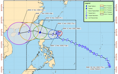
“Siony” now packs a maximum sustained winds of 85 kilometers per hour (kph) near the center, and gustiness of up to 105 kph. It was last seen 565 kilometers (km) east of Basco, Batanes, slowly moving east northeastward.
The Philippine Atmospheric, Geophysical and Astronomical Services Administration (PAGASA) forecast “Siony” to intensify into a severe tropical storm in the next 24 to 36 hours, and may reach the typhoon category on Thursday. It may also make landfall over extreme Northern Luzon.
Meanwhile, the northeasterlies and the trough of “Siony” will continue to bring light to moderate with at times heavy rains over Batanes, Apayao, Cagayan, and Isabela.
Further, the northeasterlies enhanced by the two tropical storms will cause strong to near gale conditions with higher gusts over Batanes, Babuyan Islands, and the northern portion of Cagayan and Ilocos Norte.
“Rolly” was last seen 540 km west of Subic, Zambales, and is forecast to exit PAR on Tuesday.
Rough to very rough seas will prevail over the seaboards of Northern Luzon.
Moderate to rough seas will be experienced over the remaining seaboards of Luzon, and the eastern seaboards of Visayas and Mindanao, PAGASA said. (PNA)
