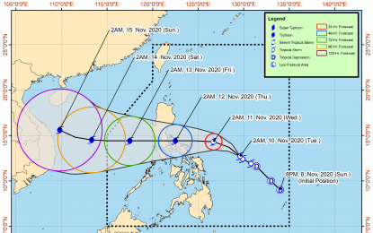
Track of Tropical Storm Ulysses (Image from PAGASA)
MANILA – Several parts of Bicol Region, eastern portion of Northern Samar and Quezon province are now under Tropical Cyclone Wind Signal (TCWS) No. 1 as Tropical Storm Ulysses (international name: Vamco) maintained its strength, the weather bureau said Tuesday.
In its 5 a.m. severe weather bulletin, the Philippine Atmospheric, Geophysical and Astronomical Services Administration (PAGASA) said TCWS No. 1 is hoisted over Catanduanes, Camarines Norte, Camarines Sur, Albay, Sorsogon, the eastern portion of Masbate (Aroroy, Pio V. Corpuz, Cataingan, Palanas, Uson, Dimasalang, Masbate City, Mobo, Baleno) including Ticao and Burias Islands, and the southeastern portion of Quezon (Guinayangan, Tagkawayan, Buenavista, San Andres, San Narciso.
In the Visayas, areas placed under TCWS No. 1 are Northern Samar, the northern portion of Samar (Santo Nino, Almagro, Tagapul-An, Tarangnan, Calbayog City, Santa Margarita, Gandara, Pagsanghan, San Jorge, San Jose de Buan, Matuguinao), and the northern portion of Eastern Samar (Maslog, Dolores, Oras, San Policarpo, Arteche, Jipapad).
More areas in these regions will most likely be placed under Signal No. 1 within the day while Signal No. 2 may be hoisted in some areas of Bicol Region as early as tonight.
Based on the intensity forecast, the highest wind signal to be hoisted during the passage of "Ulysses" will be Signal No. 3.
At 4 a.m. Tuesday, "Ulysses" was last observed at 555 kilometers east of Virac, Catanduanes. It packs maximum sustained winds of 65 kilometer per hour (kph) near the center and gustiness of up to 80 kph.
The tail-end of a cold front will bring light to moderate and heavy rains over Cagayan including Babuyan Islands, Isabela, and Apayao.
"Ulysses" will bring light to heavy rains over Aurora, Quezon, Bicol Region, Eastern Visayas, Caraga, and Davao Region.
It is expected to cause rough to very rough seas over the seaboards of Aurora, northern Quezon (including the northern and eastern coastal waters of Polillo Islands) and Camarines Norte, the northern seaboard of Camarines Sur, the eastern seaboards of Albay (including Rapu-Rapu Islands), Sorsogon, and Eastern Samar, and the northern and eastern seaboards of Catanduanes and Northern Samar.
Sea travel is risky over these waters, especially for mariners of small seacraft.
In the next 24 hours, rough to very rough seas may be experienced over the entire seaboards of Northern Luzon and the seaboards of Kalayaan Islands due to the surge of the northeast monsoon, according to PAGASA.
Moderate to rough seas will be experienced over the western seaboards of Central and Southern Luzon, and the eastern seaboard of Mindanao. PAGASA advised mariners of small seacraft to take precautionary measures when venturing to the sea.
PAGASA forecast "Ulysses" to intensify into a severe tropical storm later and into a typhoon category by Wednesday. It may make landfall over Quezon between Wednesday and Thursday.
A landfall over Bicol Region around Wednesday remains a possibility, the bureau added.
Meanwhile, "Ulysses" will bring light to moderate with at times heavy rains over Aurora, Quezon, Bicol Region, Eastern Visayas, Caraga, and Davao Region.
The tail-end of a cold front, on the other hand, will cause light to moderate with at times heavy rains over Cagayan, including Babuyan Islands, the eastern portion of Isabela, and Apayao.
Flooding, rain-induced landslides, and sediment-laden streamflows may occur during heavy or prolonged rainfall, PAGASA said. (PNA)
