(File photo)
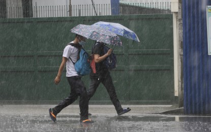
MANILA – The southwest monsoon enhanced by Severe Tropical Storm (STS) Fabian and the weather disturbance outside the Philippine Area of Responsibility (PAR) with international name "Cempaka" will continue to dampen parts of Luzon Tuesday.
In its 5 a.m. tropical cyclone bulletin, the Philippine Atmospheric, Geophysical and Astronomical Services Administration (PAGASA) said monsoon rains will pour over Ilocos Region, Cordillera Administrative Region, Cagayan Valley, Zambales, Bataan, Occidental Mindoro and Palawan.
Flash floods or landslides are possible due to scattered to widespread moderate to at times heavy rains.
The enhanced southwest monsoon will cause rough to very rough seas over the seaboards of Batanes and the Babuyan Islands, and the western seaboard of Palawan (including Kalayaan and Calamian Islands) and Occidental Mindoro (including Lubang Islands).
Sea travel is risky for small seacrafts, while mariners without the proper experience should immediately seek safe harbor.
"Fabian" is unlikely to bring heavy rainfall, PAGASA said.
The STS was last seen 1,035 kilometers east northeast of extreme Northern Luzon, slowly moving west-northwestward. It packs maximum sustained winds of 95 kilometers per hour (kph) near the center and gustiness of up to 115 kph.
Meanwhile, scattered rain showers and thunderstorms are expected over Metro Manila, Calabarzon, the rest of Mimaropa, and Western Visayas.
The rest of the country will have rain showers or thunderstorms, still due to the southwest monsoon.
Light to moderate winds and slight to moderate seas will prevail over the archipelago, except over the northern and western section of Luzon where moderate to strong winds and moderate to rough seas will prevail. (PNA)
