(File photo)
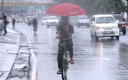
MANILA – Most areas in Luzon will experience rains due to the southwest monsoon or habagat enhanced by a low pressure area (LPA) outside the Philippine Area of Responsibility (PAR), a weather forecaster said Tuesday.
In its latest weather update, the Philippine Atmospheric, Geophysical and Astronomical Services Administration (PAGASA) said the LPA was last seen 615 kilometers north of extreme Northern Luzon.
"The southwest monsoon continues to bring rains over the country, especially over most parts of Luzon. The LPA outside PAR also continues to enhance the habagat," weather forecaster Meno Mendoza said.
Monsoon rains will also dampen the Ilocos Region, Batanes, Babuyan Group of Islands, Abra, Apayao, Benguet, Zambales and Bataan.
PAGASA forecast moderate to heavy rains over Batanes and Babuyan Group of Islands, and light to moderate with at times heavy rains over Ilocos Region, Apayao, Abra, and Benguet. This condition may last in the next 24 hours, it said.
Flash floods and rain-induced landslides are possible during heavy or prolonged rainfall, especially in areas highly susceptible to these hazards.
Occasional rains are expected over Metro Manila, Tarlac, Pampanga, Bulacan, Occidental Mindoro and the rest of Cordillera Administrative Region and Cagayan Valley.
Flash floods or landslides are also likely during moderate to at times heavy rains.
Moderate to strong winds and moderate to rough seas still prevail over Luzon and the Visayas.
Over Mindanao, winds will be light to moderate with slight to moderate seas.
Mendoza said PAGASA is also monitoring two tropical depressions outside PAR.
"Both are not expected to enter PAR. One will move away towards Japan, while the other one may enhance the southwest monsoon in the next few days," he said. (PNA)
