(Image grabbed from PAGASA's Facebook page)
MANILA – Typhoon Kiko maintained its strength as it threatens extreme northern Luzon, the weather bureau said Friday.
In its 8 a.m. bulletin, the Philippine Atmospheric, Geophysical and Astronomical Services Administration (PAGASA) said “Kiko”, packing maximum sustained winds of 185 kilometers per hour near the center and gustiness of up to 230 kph was last located 235 km. east northeast of Casiguran, Aurora.
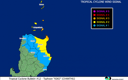
Tropical Cyclone Wind Signal (TCWS) No. 3 has been hoisted over extreme northeastern portion of Cagayan (Santa Ana) and the eastern portion of Babuyan Islands (Babuyan Is., Didicas Is., Camiguin Is., and Pamuktan Island)
These areas may experience destructive typhoon-force winds.
TCWS no. 2 has been hoisted over the following areas where damaging gale-force to storm-force winds will prevail: Batanes, the rest of Babuyan Islands, the remaining eastern portion of mainland Cagayan (Aparri, Camalaniugan, Lal-Lo, Gattaran, Baggao, Peñablanca, Buguey, Santa Teresita, Gonzaga, Tuguegarao City, Iguig, Amulung, Alcala, Allacapan, Lasam, Ballesteros, Abulug) and the northeastern portion of Isabela (San Pablo, Maconacon, Divilacan, Palanan)
Strong winds will be experienced in areas under TCWS no. 1 — the rest of mainland Cagayan, the eastern portion of Ilocos Norte (Pagudpud, Adams, Dumalneg, Bangui, Vintar, Carasi, Nueva Era, Burgos), Apayao, the northern portion of Kalinga (Balbalan, Pinukpuk, City of Tabuk, Rizal), the eastern portion of Mountain Province (Paracelis), the northeastern portion of Abra (Tineg, Lacub, Malibcong), the northwestern and southeastern portions of Isabela (Santa Maria, Quezon, Mallig, Roxas, San Manuel, Cabatuan, Aurora, City of Cauayan, Angadanan, San Guillermo, Dinapigue, San Mariano, Cabagan, Santo Tomas, Delfin Albano, Tumauini, Quirino, Burgos, Gamu, Ilagan City, Luna, Reina Mercedes, Naguilian, Benito Soliven), and the northern portion of Aurora (Dilasag, Casiguran)
"Kiko" and Severe Tropical Storm Conson (outside the Philippine Area of Responsibility) are enhancing the southwest monsoon.
As such, monsoon rains will be experienced over the western sections of central Luzon and southern Luzon, and the Visayas in the next 24 hours, PAGASA said.
Heavy to intense, with at times torrential rains caused by "Kiko" are forecast over Cagayan including Babuyan Islands, Batanes, and northern Isabela.
Moderate to heavy, with at times intense rains may also prevail over Ilocos Region, Cordillera Administrative Region, northern and central Aurora, and the rest of Cagayan Valley.
Scattered to widespread flooding and rain-induced landslides are possible, especially in areas susceptible to these hazards.
Meanwhile, rough to very high seas will be experienced over the seaboards of areas where TCWS is in effect sea travel is risky for all types of sea vessels.
Moderate to rough seas will prevail over the eastern seaboards of central and southern Luzon. Sea travel is risky for those using small seacraft, PAGASA said. (PNA)
