(Image grabbed from PAGASA's Facebook page)
MANILA – Typhoon Odette further weakened as it made another landfall in the vicinity of Carcar, Cebu, the Philippine Atmospheric, Geophysical and Astronomical Services Administration (PAGASA) said Thursday night.
In its 11 p.m. tropical cyclone bulletin, the weather bureau said the center of the eye of Typhoon Odette was located in the vicinity of Carcar with maximum sustained winds of 175 kilometers per hour near the center, and gustiness of up to 240 kph.
The typhoon earlier made landfalls over Siargao Island, Surigao del Norte at 1:30 p.m.; Cagdianao, Dinagat Islands (3:10 p.m.); Liloan, Southern Leyte (4:50 p.m.); Padre Burgos, Southern Leyte (5:40 p.m.); Pres. Carlos P. Garcia, Bohol (6:30 p.m.); and Bien Unido, Bohol (7:30 p.m.)
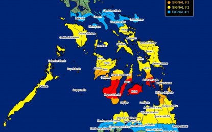
PAGASA said Tropical Cyclone Wind Signal (TCWS) No. 4 is still hoisted over The western portion of Bohol (Balilihan, Catigbian, Loon, San Isidro, Antequera, Maribojoc, Cortes, Clarin, Calape, Tubigon, Sagbayan, Danao, Inabanga, Getafe, Buenavista, Talibon, Trinidad, Bien Unido), the central and southern portions of Cebu (Lapu-Lapu City, Cordova, Cebu City, Mandaue City, Consolacion, Liloan, Toledo City, City of Talisay, Minglanilla, City of Naga, Pinamungahan, San Fernando, City of Carcar, Aloguinsan, Barili, Sibonga, Dumanjug, Ronda, Argao, Alcantara, Moalboal, Badian, Dalaguete, Alcoy, Alegria, Malabuyoc, Boljoon, Oslob, Ginatilan, Samboan, Santander), the northern and central portions of Negros Oriental (Canlaon City, Vallehermoso, City of Guihulngan, La Libertad, Jimalalud, Tayasan, Ayungon, Bindoy, Manjuyod, Mabinay, City of Bayawan, Basay, Bais City, Pamplona, San Jose, City of Tanjay, Amlan), and the central and southern portions of Negros Occidental (La Castellana, Pontevedra, Hinigaran, Moises Padilla, Isabela, Binalbagan, City of Himamaylan, City of Kabankalan, Ilog, Cauayan, Candoni, City of Sipalay, Hinoba-An)
Areas under TCWS No. 3 will experience destructive typhoon-force winds: The northern portion of Palawan (El Nido, Taytay, Araceli, Dumaran, Roxas, San Vicente) including Cagayancillo and Cuyo Islands and the southern portion of Leyte (Bato, Matalom, Hilongos, Hindang, City of Baybay, Inopacan), the western portion of Southern Leyte (Padre Burgos, Tomas Oppus, Macrohon, City of Maasin, Limasawa, Malitbog, Bontoc), the northern portion of Cebu (Tuburan, Catmon, Carmen, Danao City, Asturias, Balamban, Dalaguete, Sogod) including Camotes Islands, the rest of Bohol, the rest of Negros Oriental, Siquijor, the northern portion of Negros Occidental (Calatrava, San Carlos City, Salvador Benedicto, City of Talisay, Silay City, Bacolod City, Murcia, Bago City, Valladolid, Pulupandan, La Carlota City, San Enrique), Guimaras, the southern portion of Iloilo (Iloilo City, Pavia, Leganes, Santa Barbara, San Miguel, Alimodian, Oton, Leon, Tigbauan, Tubungan, Igbaras, Guimbal, Miagao, San Joaquin, Dumangas, Zarraga, New Lucena, Cabatuan, Maasin), and the southern portion of Antique (San Remigio, Patnongon, Belison, San Jose, Sibalom, Hamtic, Tobias Fornier, Anini-Y).
TCWS No. 2 has been hoisted over Albay, Sorsogon, Masbate including Ticao and Burias Islands, Romblon, Oriental Mindoro, Occidental Mindoro, the rest of Palawan including Calamian and Kalayaan Islands, Norrthern Samar, Eastern Samar, Samar, Biliran, the rest of Leyte, the rest of Southern Leyte, the rest of Cebu including Bantayan Islands, the rest of Negros Occidental, the rest of Iloilo, Capiz, Aklan, and the rest of Antique, Dinagat Islands, Surigao del Norte, the northern portion of Surigao del Sur (Lanuza, Carmen, Madrid, Cantilan, Carrascal, San Miguel, Cortes, City of Tandag), Agusan del Norte, the northern portion of Agusan del Sur (Esperanza, Sibagat, San Luis, City of Bayugan), Misamis Oriental, Camiguin, the northern portion of Bukidnon (Talakag, Impasug-Ong, Baungon, Sumilao, Manolo Fortich, Malitbog, Libona), Lanao del Norte, Misamis Occidental, and the extreme northern portion of Zamboanga del Norte (Dapitan City, Siayan, Sindangan, Jose Dalman, Manukan, Pres. Manuel A. Roxas, Katipunan, Sergio Osmeña Sr., Polanco, Dipolog City, Piñan, Mutia, La Libertad, Rizal, Sibutad)
Catanduanes, Camarines Norte, Camarines Sur, Marinduque, the southern portion of Quezon (San Antonio, Tiaong, Candelaria, Sariaya, Dolores, Lucena City, Pagbilao, Padre Burgos, Atimonan, Agdangan, Unisan, Gumaca, Plaridel, Pitogo, Lopez, Guinayangan, Buenavista, Catanauan, General Luna, Macalelon, Mulanay, San Narciso, San Andres, San Francisco, Tagkawayan, Calauag, Quezon, Alabat, City of Tayabas, Perez), Batangas, the rest of Surigao del Sur, the rest of Agusan del Sur, the rest of Bukidnon, Lanao del Sur, the rest of northern portion of Zamboanga del Norte (Labason, Kalawit, Tampilisan, Liloy, Salug, Godod, Bacungan, Gutalac, Baliguian), the rest of northern portion of Zamboanga del Sur (Bayog, Lakewood, Kumalarang, Guipos, Dumalinao, Tukuran, Ramon Magsaysay, Aurora, Sominot, Tigbao, Labangan, Pagadian City, Midsalip,), and the northern portion of Zamboanga Sibugay (Titay, Ipil, Naga, Kabasalan, Siay, Diplahan, Buug) are under TCWS No. 1.
Central and Western Visayas will experience heavy to torrential rains until Friday morning while moderate to heavy with at times intense rains will occur over Eastern Visayas, Zamboanga del Norte, Lanao del Norte, Palawan, and Bicol Region. Light to moderate with at times heavy rains over Quezon, and the rest of MIMAROPA and the rest of Mindanao.
PAGASA said areas under TCWS No. 4 will have very destructive typhoon-force winds of up to 175 kph while destructive typhoon-force winds will be experienced within any of the areas where TCWS No. 3 is in effect.
Because of the threats of Typhoon Odette, 113 flights between Manila and various domestic routes were canceled as of 1:45 p.m. Thursday. (PNA)
