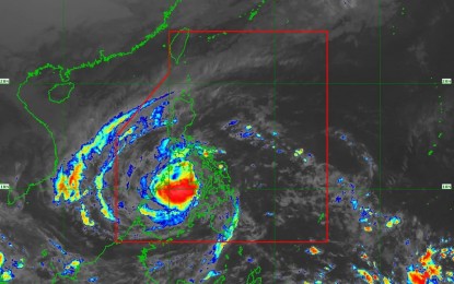
(Satellite image from PAGASA)
MANILA – Heavy rains will be experienced over Western Visayas and northern Palawan as Typhoon Odette traverses over the Sulu Sea between Cuyo and Cagayancillo islands.
In its 8 a.m. bulletin, the weather bureau said "Odette" was last tracked 155 kilometers west southwest of Iloilo City, or 90 km. south southeast of Cuyo, Palawan. The typhoon packs maximum sustained winds of 155 kph near the center and gustiness of up to 235 kph.
Destructive typhoon-force winds will prevail over the northern portion of Palawan where Tropical Cyclone Wind Signal (TCWS) No. 3 has been hoisted: El Nido, Taytay, Araceli, Dumaran, Roxas, San Vicente, Puerto Princesa City) including Cagayancillo and Cuyo Islands.
In the Visayas, TCWS no. 3 has also been hoisted over Guimaras, the southern portion of Iloilo (Tigbauan, Leon, Tubungan, Guimbal, Igbaras, Miagao, San Joaquin), the southern portion of Antique (Patnongon, San Remigio, San Jose, Belison, Sibalom, Hamtic, Tobias Fornier, Anini-Y)
TCWS no. 2 has been hoisted over southern portion of Oriental Mindoro (Bansud, Bulalacao, Roxas, Bongabong, Mansalay), the southern portion of Occidental Mindoro (Rizal, San Jose, Magsaysay, Calintaan, Sablayan), the western portion of Romblon (Looc, Ferrol, Santa Fe, San Jose, Alcantara, Santa Maria, Odiongan, San Agustin, San Andres, Calatrava), and the central portion of Palawan (Narra, Sofronio Española, Quezon, Aborlan, Rizal, Brooke's Point) including Kalayaan and Calamian Islands, Aklan, Capiz, the rest of Iloilo, the rest of Antique, Guimaras, Negros Oriental, Negros Occidental, and the southern portion of Cebu (Toledo City, Pinamungahan, San Fernando, City of Carcar, Aloguinsan, Barili, Sibonga, Dumanjug, Argao, Ronda, Alcantara, Moalboal, Badian, Dalaguete, Alegria, Alcoy, Malabuyoc, Boljoon, Oslob, Ginatilan, Samboan, Santander)
These areas will have damaging gale to storm-force winds.
Strong winds will prevail over areas under TCWS no. 1: western portion of Camarines Sur, Albay (Del Gallego, Ragay, Lupi, Sipocot, Libmanan, Cabusao, Calabanga, Bombon, Magarao, Canaman, Pamplona, Camaligan, Gainza, Pasacao, Naga City, Milaor, San Fernando, Pili, Ocampo, Sagñay, Buhi, Iriga City, Baao, Bula, Minalabac, Nabua, Balatan, Bato), Sorsogon, Masbate including Ticao and Burias Islands, Marinduque, the southern portion of Quezon (San Antonio, Tiaong, Candelaria, Sariaya, Dolores, Lucena City, Pagbilao, Padre Burgos, Atimonan, Agdangan, Unisan, Gumaca, Plaridel, Pitogo, Lopez, Guinayangan, Buenavista, Catanauan, General Luna, Macalelon, Mulanay, San Narciso, San Andres, San Francisco, Tagkawayan, Calauag, Quezon, Alabat, City of Tayabas, Perez), the rest of Occidental Mindoro including Lubang Islands, the rest of Oriental Mindoro, the rest of Palawan, the rest of Romblon, and Batangas.
Also under TCWS no. 1 are the western portion of Northern Samar (Lope de Vega, Catarman, Bobon, San Jose, Rosario, Lavezares, Biri, Allen, Victoria, San Isidro, San Antonio, Capul, San Vicente), the western portion of Samar (Calbayog City, Santa Margarita, Gandara, Pagsanghan, Tarangnan, San Jorge, City of Catbalogan, Zumarraga, Daram, Talalora, Villareal, Santa Rita, Santo Niño, Almagro, Tagapul-An), Bohol, Biliran, Leyte, the western portion of Southern Leyte (Sogod, Tomas Oppus, Bontoc, Malitbog, Padre Burgos, Macrohon, City of Maasin, Limasawa), the rest of Cebu including Bantayan and Camotes Islands, and Siquijor, the northern portion of Zamboanga del Norte (Baliguian, Gutalac, Kalawit, Labason, Liloy, Tampilisan, Salug, Godod, Bacungan, Sindangan, Siayan, Jose Dalman, Manukan, Pres. Manuel A. Roxas, Katipunan, Sergio Osmeña Sr., Dipolog City, Polanco, Piñan, Mutia, Dapitan City, La Libertad, Sibutad, Rizal), and the northern portion of Misamis Occidental (Don Victoriano Chiongbian, Aloran, Oroquieta City, Lopez Jaena, Concepcion, Sapang Dalaga, Calamba, Baliangao, Plaridel).
Moderate to very high seas will be experienced over the seaboards of areas where wind signals are in effect.
The Philippine Atmospheric, Geophysical and Astronomical Services Administration (PAGASA) said heavy to torrential rains will pour over Western Visayas, Palawan including Calamian, Cuyo, and Cagayancillo islands, and Negros Oriental.
Moderate to heavy, with at times intense rains are likely over the Bicol region, Zamboanga Peninsula, Quezon, and the rest of Mimaropa.
Light to moderate, with at times heavy rains over will be experienced over Metro Manila, Cagayan Valley, Cordillera Administrative Region, Caraga, Northern Mindanao, Aurora, Lanao del Sur, and the rest of the Visayas.
Gale warning remains in effect for several coastal waters not under any TCWS, specifically the seaboard of northern Luzon, and the eastern seaboards of the country. Further, moderate to rough seas are likely over the remaining seaboards of the country.
“Odette” may make landfall in the vicinity of the northern or central portion of Palawan on Friday. (PNA)
