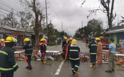
AFTERMATH. The Bureau of Fire Protection in Region 6 (Western Visayas) presides over road-clearing operations in this photo uploaded on Facebook on Friday (Dec. 17, 2021). Typhoon Odette is still in Palawan as of Friday night and is forecast to exit the Philippine Area of Responsibility Saturday morning (December 18) or early afternoon. (Photo courtesy of BFP Facebook)
MANILA – Tropical cyclone wind signal (TCWS) No. 3 remained hoisted over Northern Palawan even as Typhoon Odette slightly weakened on Friday night.
The Philippine Atmospheric, Geophysical and Astronomical Services Administration (PAGASA) said “Odette” still packs maximum sustained winds of 150 kilometers per hour (kph) near the center and gustiness of up to 205 kph as of 8 p.m.
Odette made landfall over Roxas, Palawan at 3:10 p.m. and was last tracked over the coastal waters of San Vicente.
Destructive typhoon-force winds will prevail in areas under TCWS No. 3 -- northern portion of Palawan (El Nido, Taytay, Araceli, Dumaran, Roxas, San Vicente, Puerto Princesa City), including Kalayaan Islands
Areas under TCWS No. 2 will have damaging gale to storm-force winds: central portion of Palawan (Narra, Sofronio Española, Quezon, Aborlan, Rizal, Brooke's Point), including Calamian, Cuyo, and Cagayancillo Islands.
The rest of Palawan is under TCWS No. 1 and will experience strong winds prevailing or expected within 36 hours.
Tonight, PAGASA forecasts heavy to torrential rains over Palawan including Calamian, Cuyo, and Cagayancillo Islands; moderate to heavy with at times intense rains over Bicol Region, Quezon, and the rest of Mimaropa; and light to moderate with at times heavy rains over Cagayan Valley, Cordillera Administrative Region, Central Luzon, and the rest of Calabarzon.
Over the West Philippine Sea, the typhoon is forecast to move west northwestward and may exit the Philippine Area of Responsibility Saturday morning or early afternoon. (PNA)
Over the West Philippine Sea, the typhoon is forecast to move west northwestward and may exit the Philippine Area of Responsibility Saturday morning or early afternoon. (PNA)
