(Image courtesy of DOST-PAGASA)
MANILA – Cloudy skies with scattered rain showers and thunderstorms will prevail over Bicol Region, Quezon, and Kalayaan Islands due to Typhoon Odette, the Philippine Atmospheric, Geophysical and Astronomical Services Administration (PAGASA) said Sunday.
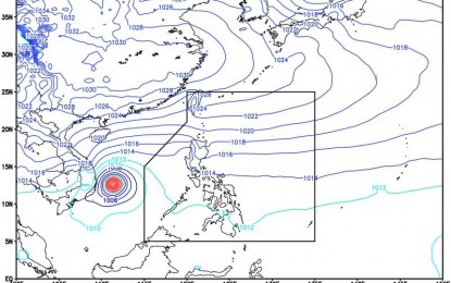
In its 5 a.m. bulletin, the weather bureau said the center of “Odette” was at 320 kilometers northwest of Pag-asa Island in West Philippine Sea (WPS). It is now outside the Philippine area of responsibility (PAR) based on all available data.
It has maximum sustained winds of 195 kilometers per hour (kph) near the center and gustiness of up to 240 kph. It is moving west northwestward at 25 kph with the shear line (tail-end of frontal system) affecting the eastern section of Luzon.
In another weather bulletin issued late Saturday, the center of Odette was seen 380 kilometers northwest of Puerto Princesa City, packing maximum sustained winds of 155 kph with gustiness of 190 kph.
Metro Manila, Central Luzon, Cagayan Valley, and the rest of Calabarzon will have cloudy skies with rains caused by northeast monsoon (amihan) while Ilocos Region and Cordillera Administrative Region will experience partly cloudy to cloudy skies with isolated light rains caused by northeast monsoon.
Meantime, the rest of the country will have partly cloudy to cloudy skies with isolated rain showers or thunderstorms due to localized thunderstorm.
The PAGASA warned residents living in affected areas against possible flash floods or landslides during severe thunderstorms.
Moderate to strong winds moving northeast to east will blow over Luzon with moderate to rough coastal waters.
Light to moderate winds moving northeast to southeast will blow over Mindanao with slight to moderate coastal waters.
The minimum temperature is 24.9°C while the maximum temperature is 33.6 °C. (PNA)
