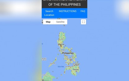
MANILA – The Civil Aviation Authority of the Philippines (CAAP) on Thursday launched the critical areas virtual map, which would guide individuals planning to construct buildings or put up towers if the structure's height is compliant with government requirements around airports.
"It can be used as a guide for any interested persons, especially telecommunication companies, before they propose for the construction of a building or telecommunication towers," CAAP spokesperson Eric Apolonio told the Philippine News Agency in an interview.
The critical areas map would identify whether a proposed structure would pose a hazard to air navigation.
"CAAP is the national authority that issues height clearance permits regulating standards for determining obstructions around airports and in navigable airspace that apply to existing and proposed man-made structures such as telecommunication towers," he explained.
Apolonio added that CAAP, along with other agencies, streamlined the guidelines for the issuance of permits and clearances for the construction of poles and underground fiber ducts, and installation of aerial and underground cables and facilities to accelerate the rollout of telecommunications and internet infrastructure.
Those applying for permits must personally go to the CAAP central office.
"There are many documentary requirements and they are not sure if (the height of the structure is compliant). (Having this online platform would enable them) to check in real-time if the application is compliant," he said.
Companies that intend to build structures in the provinces would have to go to the CAAP central office in Pasay City to submit their application, Apolonio clarified.
The map can be accessed online by accessed through the CAAP's website, http://www.caap.gov.ph/. Click "Other Services," select the Height Clearance icon, then click "CAAP Critical Areas". (PNA)
