(Courtesy of PAGASA/DOST)
MANILA – Tropical Cyclone Wind Signal (TCWS) Nos. 2 and 1 have been hoisted over more areas as Tropical Storm (TS) Florita maintains its strength, the weather bureau said Monday afternoon.
Cagayan, Isabela, Quirino, the eastern portion of Nueva Vizcaya (Alfonso Castaneda, Dupax del Norte, Kasibu, Quezon, Bambang, Ambaguio, Bayombong, Solano, Villaverde, Bagabag, Diadi), Apayao, the eastern portion of Abra (Tubo, Boliney, Bucloc, Daguioman, Sallapadan, Licuan-Baay, Malibcong, Lacub, Tineg, Lagangilang, Bucay, Manabo, Luba), Kalinga, Mountain Province, Ifugao, and the northern and central portions of Aurora (Dilasag, Casiguran, Dinalungan, Dipaculao, Baler, Maria Aurora) were put under TCWS No. 2.
The Philippine Atmospheric, Geophysical and Astronomical Services Administration (PAGASA) said these areas will experience winds that may reach gale-force in strength.
Areas under Signal No. 1 are Babuyan Islands, the rest of Nueva Vizcaya, the rest of Abra, Benguet, Ilocos Norte, Ilocos Sur, La Union, the eastern portion of Pangasinan (Urbiztondo, Bayambang, Bautista, Alcala, Santo Tomas, Rosales, Balungao, Umingan, San Quintin, Natividad, Tayug, San Nicolas, San Manuel, Asingan, San Carlos City, Lingayen, Binmaley, Basista, Malasiqui, Villasis, Santa Maria, City of Urdaneta, Binalonan, Laoac, Manaoag, Pozorrubio, Sison, San Fabian, San Jacinto, Mapandan, Santa Barbara, Mangaldan, Dagupan City, Calasiao), the eastern portion of Tarlac (San Manuel, Moncada, Anao, Paniqui, Ramos, Gerona, Pura, Victoria, City of Tarlac, Concepcion, La Paz).
Also under Signal No. 1 are Nueva Ecija, the rest of Aurora, the eastern portion of Pampanga (Magalang, Arayat, Candaba), the eastern portion of Bulacan (San Miguel, Doña Remedios Trinidad, San Ildefonso, San Rafael, Angat, Norzagaray, City of San Jose del Monte), the northeastern portion of Rizal (Rodriguez, San Mateo, City of Antipolo, Tanay, Baras), the northern portion of Quezon (Infanta, General Nakar, Real) including Polillo Islands, the northern portion of Laguna (Santa Maria, Famy, Siniloan, Pangil, Pakil, Paete) and Camarines Norte.
Strong breeze to near gale strength winds will be experienced in these areas.
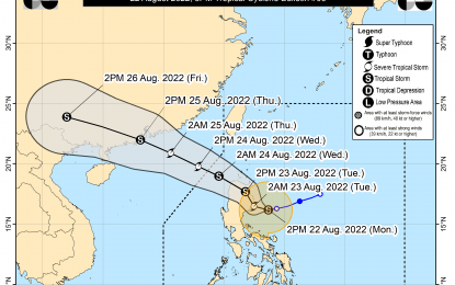
"Florita" was last tracked 155 kilometers east of Casiguran, Aurora, moving westward at 15 kph.
It has maintained its strength, packing maximum sustained winds of 75 kph near the center and gustiness of up to 90 kph.
The TS will continue to bring moderate to heavy with at times intense rains over Camarines Norte, Camarines Sur and Quezon, including Polillo Islands.
Moderate to heavy rains continue to prevail over Ilocos Region, Apayao, and Cagayan.
Light to moderate, with at times heavy rains will continue over Central Luzon, Batanes, Isabela, Mindoro provinces, Romblon, Marinduque, Metro Manila, and the rest of Calabarzon, and Bicol Region.
Meanwhile, PAGASA said "Florita" will bring moderate to rough seas over the western seaboards of Northern and Central Luzon, and the eastern seaboards of the Visayas and Mindanao in the next 24 hours.
These conditions may be risky for those using small seagoing vessels. Mariners are advised to take precautionary measures when venturing out to the sea, and if possible, avoid navigating in these conditions, it added. (PNA)
