MANILA – Tropical Cyclone Wind Signal (TCWS) No. 3 has been hoisted over the northern and eastern portion of mainland Cagayan as "Florita" intensifies into a severe tropical storm, the weather bureau said Tuesday.
"Florita" now packs maximum sustained winds of 95 kph near the center, and gustiness of up to 115 kph.
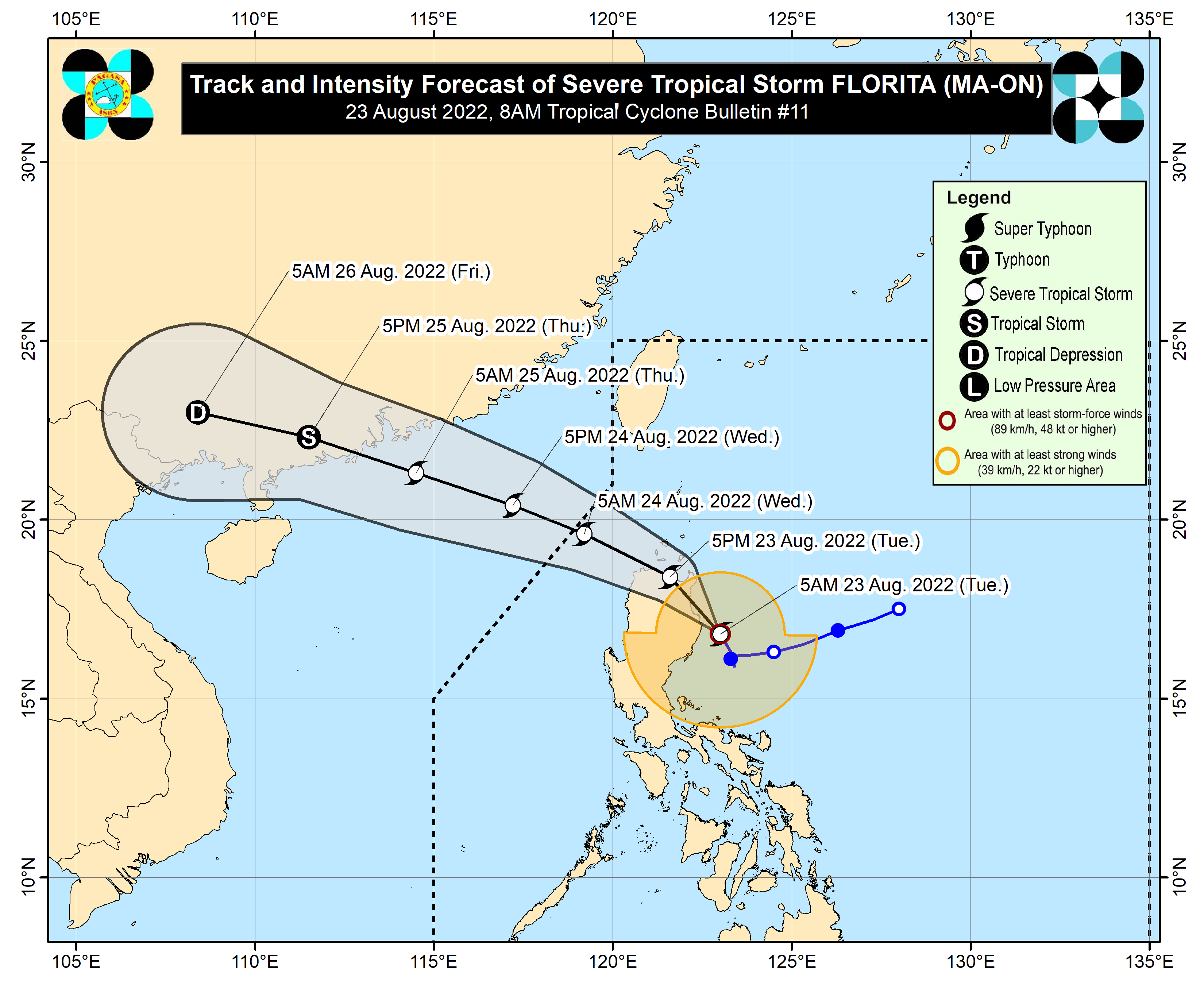
In its 5 a.m. bulletin, the Philippine Atmospheric, Geophysical and Astronomical Services Administration (PAGASA) said "Florita" was last tracked 120 kilometers east northeast of Casiguran, Aurora, moving north northwestward at 10 kph.
Signal No. 3 has been hoisted over Santa Praxedes, Claveria, Sanchez-Mira, Pamplona, Abulug, Ballesteros, Lal-Lo, Baggao, Peñablanca, Gattaran, Aparri, Camalaniugan, Buguey, Santa Ana, Gonzaga, Santa Teresita) and the eastern portion of Isabela (Maconacon, Divilacan, Palanan).
The rest of Cagayan including Babuyan Islands, the rest of Isabela, Quirino, the eastern and central portions of Nueva Vizcaya (Kayapa, Ambaguio, Solano, Villaverde, Bagabag, Diadi, Quezon, Bayombong, Bambang, Aritao, Dupax del Sur, Dupax del Norte, Kasibu, Alfonso Castaneda), Apayao, Abra, Kalinga, Mountain Province, Ifugao, the northern portion of Benguet (Bakun, Kibungan, Buguias, Kabayan, Mankayan, Bokod, Atok), Ilocos Norte, Ilocos Sur, and the northern and central portions of Aurora (Dilasag, Casiguran, Dinalungan, Dipaculao, Baler, Maria Aurora) were put under Signal No. 2.
Areas under Signal No. 1 are Batanes, the rest of Nueva Vizcaya, the rest of Benguet, La Union, Pangasinan, the eastern portion of Tarlac (San Clemente, Camiling, Moncada, San Manuel, Anao, Santa Ignacia, Gerona, Paniqui, Ramos, Pura, Victoria, La Paz, City of Tarlac, Concepcion), Nueva Ecija, the rest of Aurora, the eastern portion of Pampanga (Magalang, Arayat, Candaba), the eastern portion of Bulacan (San Ildefonso, San Miguel, Doña Remedios Trinidad, San Rafael, Angat, Norzagaray, City of San Jose del Monte), the eastern portion of Rizal (Rodriguez, San Mateo, City of Antipolo, Tanay, Baras), the northern portion of Quezon (General Nakar, Infanta, Real, Mauban, Perez, Alabat, Quezon, Calauag) including Polillo Islands, the northern portion of Laguna (Santa Maria, Famy, Siniloan, Pangil, Pakil, Paete), and Camarines Norte.
On Tuesday, heavy to intense, with at times torrential rains will be experienced over Cagayan, Isabela, Cordillera Administrative Region, Ilocos Region, and Zambales.
Moderate to heavy, with at times intense rains will prevail over the northern portion of Aurora, Bataan, Tarlac, and the rest of Cagayan Valley.
Light to moderate, with at times heavy rains are likely over Metro Manila, Region 4-A (Calabarzon), Camarines Norte, and the rest of Central Luzon.
Scattered to widespread flooding and rain-induced landslides are expected, especially in areas highly susceptible to these hazards.
Meanwhile, PAGASA said winds may reach storm-force in strength in areas under Signal No. 3, while winds may reach gale-force in strength in areas under Signal No. 2.
Strong winds breeze to near gale strength winds will be experienced in areas where Signal No. 1 is in effect.
Rough to high seas will prevail over the seaboards of Northern luzon (Ilocos Norte, Ilocos Sur, Batanes, Cagayan and Isabela).
Rough to very rough seas are forecast over the eastern seaboards of Central and Southern Luzon (Aurora, the eastern coast of Quezon including Polillo Island, Camarines Norte, the northern and eastern coast of Camarines Sur, and the eastern coast of Catanduanes).
"Florita" and the southwest monsoon will cause moderate to rough seas over the remaining seaboards of Southern Luzon and the Visayas in the next 24 hours.
These conditions may be risky for those using small sea vessels. PAGASA advised mariners to take precautionary measures when venturing out to the sea. (PNA)
