(Image from PAGASA as of 11 a.m. Aug. 23, 2022)
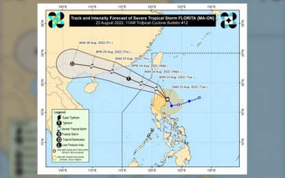
MANILA – The center of Severe Tropical Storm Florita based on all available data from the Philippine Atmospheric, Geophysical and Astronomical Services Administration (PAGASA), including those from Aparri Doppler Weather Radar, is now estimated to be over the coastal waters of Maconacon, Isabela.
It is moving northwestward at 20 kilometers per hour (kph) with maximum sustained winds of 95 kph near the center and gustiness of up to 150 kph.
"Florita" made landfall over Maconacon, Isabela at 10:30 a.m. Tuesday.
Heavy to intense with at times torrential rains will be experienced over Cagayan, Isabela, Cordillera Administrative Region (CAR), Ilocos Region, Zambales, and Bataan.
On the other hand, moderate to heavy with at times intense rains will be experienced over the northern portion of Aurora, Tarlac, Pampanga, Bulacan, Metro Manila, Cavite, Rizal, and the rest of Cagayan Valley.
Light to moderate with at times heavy rains over the rest of Central Luzon and the rest of Calabarzon.
Signal No. 3 has been hoisted over northern portion of Ilocos Norte (Pagudpud, Dumalneg, Adams, Bangui, Burgos), Apayao, the southern portion of Babuyan Islands (Camiguin Is., Fuga Is., Dalupiri Is.), mainland Cagayan, the northeastern portion of Isabela (Palanan, Divilacan, Maconacon, San Pablo, Tumauini, Cabagan, Santa Maria, Santo Tomas, Delfin Albano, Ilagan City, San Mariano).
The rest of Babuyan Islands, the rest of Isabela, Quirino, the northern and eastern portion of Nueva Vizcaya (Quezon, Diadi, Bagabag, Villaverde, Solano, Kasibu), Abra, Kalinga, Mountain Province, Ifugao, the northern portion of Benguet (Buguias, Bakun, Mankayan, Kibungan), the rest of Ilocos Norte, Ilocos Sur, and the northern portion of Aurora (Dilasag, Casiguran, Dinalungan, Dipaculao) are still under Signal No. 2.
Areas under Signal No. 1 are Batanes, the rest of Nueva Vizcaya, the rest of Benguet, La Union, the eastern portion of Pangasinan (Santo Tomas, Villasis, Mapandan, Mangaldan, San Fabian, San Jacinto, Manaoag, City of Urdaneta, Rosales, Balungao, Umingan, San Quintin, Natividad, San Nicolas, Tayug, Santa Maria, Asingan, San Manuel, Binalonan, Sison, Pozorrubio, Laoac, Dagupan City), the northeastern portion of Tarlac (San Manuel, Anao), Nueva Ecija, the rest of Aurora.
This tropical cyclone is forecast to traverse the northern portion of Isabela and mainland Cagayan. Afterwards, “Florita” will emerge over the Babuyan Channel tonight.
It is expected to exit the Philippine Area of Responsibility (PAR) Wednesday morning. (PNA)
