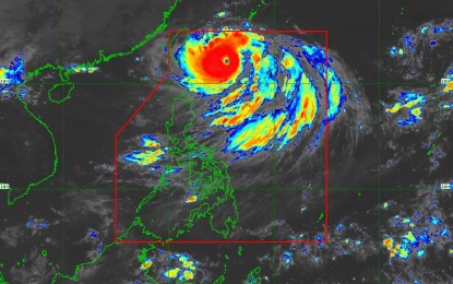
(Image grabbed from PAGASA's Facebook page)
MANILA – Super Typhoon Henry slightly intensified but no Tropical Cyclone Wind Signal (TCWS) was hoisted in any part of the country as of Thursday morning.
"TCWS may be hoisted for localities in extreme Northern Luzon by today at the earliest in anticipation of a potential strong breeze to near gale conditions. The potential for hoisting a wind signal no. 2 is also not ruled out," the Philippine Atmospheric, Geophysical and Astronomical Services Administration (PAGASA) said in its latest bulletin.
"Henry" packed maximum sustained winds of 195 kph near the center, and gustiness of up to 240 kph.
It was last tracked 430 km. east northeast of Itbayat, Batanes, moving south southwestward at 25 kph.
"Henry" may cause light to moderate rain with at times heavy rains over Batanes beginning late afternoon through Thursday night.
By Friday, it is expected to enhance the Southwest Monsoon that may cause rains over the western section of Luzon.
Rough to very rough seas still prevail over the northern and eastern seaboards of Northern Luzon (Batanes, Cagayan, and the northern coast of Ilocos Norte).
Fishing boats and other small seacraft are advised not to venture out into the sea, while large sea vessels are alerted against big waves.
In the next 24 hours, "Henry" may cause moderate to rough seas over the eastern seaboard of Isabela, PAGASA said.
Meanwhile, weather disturbance "Gardo" has weakened into a remnant low, and is not expected to directly affect the weather and sea conditions in the country. (PNA)
