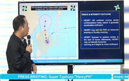
TYPHOON HENRY. PAGASA forecaster Raymond Ordinario provides the forecast track of Typhoon Henry on Friday (Sept. 2, 2022). (Screenshot from PAGASA's Facebook page)
MANILA – Typhoon Henry has further weakened as it slowly moves northwestward over the Philippine Sea, the weather bureau said.
The typhoon packed maximum sustained winds of 165 kph near the center, and gustiness of up to 205 kph. It is forecast to further weaken in the next 12 hours, based on the Philippine Atmospheric, Geophysical and Astronomical Services Administration's (PAGASA) 11 a.m. bulletin Friday.
Tropical Cyclone Wind Signal No. 1 has been hoisted over Batanes, where strong breeze to near gale strength winds will be experienced.
"Henry" will bring moderate to heavy, with at times intense rains likely over Ilocos Region, Babuyan Islands, Batanes, Apayao, and Abra.
Light to moderate, with at times heavy rains, is also forecast over Cagayan.
In the next 24 hours, the southwest monsoon will cause rains over Isabela, the western portion of Central Luzon, and the rest of Cordillera Administrative Region.
Isolated to scattered flooding and rain-induced landslides are likely, especially in areas highly susceptible to these hazards.
Strong to gale force winds, rough to very rough seas will prevail over the northern and eastern seaboards of Northern Luzon (Batanes, Cagayan including Babuyan Islands, Isabela, and the northern coast of Ilocos Norte), and the eastern seaboard of Central Luzon (Aurora).
Fishing boats and other small seacraft are advised not to venture out into the sea, while larger sea vessels are alerted against big waves.
"Henry" is expected to exit the Philippine Area of Responsibility either Saturday or Sunday, PAGASA said.
No big damage seen
While it does not expect "Henry" to bring major damage, the National Disaster Risk Reduction and Management Council (NDRRMC) said it will continue to monitor the effects of the southwest monsoon that may be enhanced by the weather disturbance.
"Hindi masyadong malaki in terms of damage kasi medyo malayo siya but we are not discounting na magkaroon ng direct damage sa agriculture dun sa Batanes and some parts of Cagayan. So antayin natin lumagpas eto because based on our protocol, saka pa lang kami gagawa ng post-disaster or rapid assessment ng effects. But so far, ang nakikita natin as far as major infrastructure is concerned, wala tayong nakikitang major damage dito kasi medyo malayo siya (The damage caused by 'Henry' is not that big as it is quite far but we are not discounting direct damage in agriculture in Batanes and some parts of Cagayan. So we will wait until it passes over because based on your protocol that is the time only when we can make post-disaster or rapid assessment of the effects. But so far, we are still to see any infrastructure damage as it quite far from us)," NDRRMC spokesperson and Office of Civil Defense (OCD) Assistant Secretary Bernardo Rafaelito Alejandro IV said in a Laging Handa briefing.
Bad weather is now experienced in Batanes and Sta. Ana, Cagayan which are near the typhoon's path.
Batanes Governor Marilou Cayco suspended work in government offices and classes at all levels on Friday due to bad weather.
Alejandro added that the threats posed by "Henry" so far are rough seas, and heavy rains in the directly affected areas.
"But tingnan pa rin natin ang epekto ng habagat na pwedeng dalhin nitong 'Henry' sa Region 1, and CAR (Cordillera Administrative Region) So yun po, babantayan natin yan kasi ngayon hanggang bukas ay mafe-feel pa natin ang effects ng pag-ulan (But we will look on the possible effects of the southwest monsoon that might be enhanced and brought by 'Henry' in Region 1 and the CAR. We will be monitoring its effects as the rains will be felt until tomorrow (Saturday)," he said.
For now, he said all NDRRMC and OCD units are ready and anticipating the possible effects of the typhoon.
"So far wala naman major reports na natanggap na may casualty tayo or meron damage except for one sa CAR, na nagkaroon daw ng landslide dun at bine-verify pa natin kung related ito sa 'Henry' yun isang casualty dun (But so far, we are still to receive any major reports telling us of casualties or damage except the one for in the CAR which was reportedly caused by a landslide. We are still verifying this to determine if this is related to the effects of 'Henry’)," he added. (PNA)
