(Image grabbed from PAGASA's Facebook page)
MANILA – The low pressure area east of Eastern Visayas has developed into Tropical Depression Paeng and is expected to bring rains over parts of the country this weekend, the weather bureau said Wednesday.
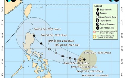
In a bulletin posted before noon, the Philippine Atmospheric, Geophysical and Astronomical Services Administration (PAGASA) said Paeng packed maximum sustained winds of 45 kph near the center, and gustiness of up to 55 kph.
It was last tracked 965 km east of Eastern Visayas.
No tropical wind signal was hoisted in any part of the country.
Paeng was forecast to cause heavy to intense with at times torrential rains possible over Bicol Region beginning Friday.
Likewise, it will bring moderate to heavy with at times intense rains over Eastern Visayas, Mindoro provinces, Marinduque, Romblon, Quezon, Aurora, Isabela and Cagayan.
Light to moderate with at times heavy rains are also likely over the Cordillera Administrative Region, Rizal, Laguna, Nueva Ecija, Bulacan, and the rest of the Visayas and Cagayan Valley.
Flooding and rain-induced landslides are possible, especially in areas highly susceptible to these hazards.
Meanwhile, PAGASA said that due to the shear line and the trough of Paeng, heavy rains are possible over Quezon, Bicol Region, the Visayas, and the northern and western portions of Mindanao.
Paeng was forecast to move northwestward on Saturday afternoon or evening and may pass close to Northern Luzon on Sunday or Monday.
PAGASA did not rule out a landfall scenario in Northern Luzon. (PNA)
