(Courtesy of PAGASA)
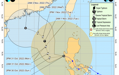
MANILA – Tropical Storm Paeng is now over the West Philippine Sea (WPS) and may exit the Philippine Area of Responsibility (PAR) on Monday morning.
In its 5 a.m. bulletin, the Philippine Atmospheric, Geophysical and Astronomical Services Administration (PAGASA) said Paeng is located 85 kilometers northwest of Iba, Zambales.
It is moving northwestward at 30 kilometers per hour with maximum sustained winds of 85 kph near the center and gustiness of up to 105 kph.
The weather bureau said moderate to heavy rains are possible over Zambales, Bataan, Aurora, Pangasinan, Batanes, and the northern portion of Cagayan including Babuyan Islands.
Light to moderate with at times heavy rains possible over Metro Manila, Cordillera Administrative Region, Calabarzon, Mimaropa, Camarines Provinces, Western Visayas, and the rest of Cagayan Valley and Central Luzon, it added.
Paeng, it said, exited the landmass of Luzon at 2 a.m. Sunday, leaving 45 people dead, including 40 in the Bangsamoro Autonomous Region in Muslim Mindanao due to flooding and landslides that displaced 115,437 families.
PAGASA lifted Tropical Cyclone Wind Signal (TCWS) No. 3 as Paeng weakened into a tropical storm as of 2 a.m. Sunday.
TCWS No. 2, however, remains hoisted over Pangasinan, La Union, the southern portion of Ilocos Sur (City of Candon, Banayoyo, Galimuyod, Sigay, Suyo, Santa Lucia, Santa Cruz, Alilem, Tagudin, Sugpon, Cervantes, Quirino, Gregorio del Pilar, Salcedo, Lidlidda, San Emilio, Santiago, Burgos, Santa Maria, San Esteban), Benguet, Tarlac, Zambales, the western portion of Bataan (Morong, Bagac, Dinalupihan, Hermosa), the western portion of Pampanga (Floridablanca, Mabalacat City, Magalang, Angeles City, Porac), and the northwestern portion of Nueva Ecija (Guimba, Cuyapo, Talugtug, Nampicuan).
Cagayan including Babuyan Islands, Isabela, Quirino, Nueva Vizcaya, Apayao, Kalinga, Ifugao, Mountain Province, Abra, Ilocos Norte, the rest of Ilocos Sur, Aurora, the rest of Nueva Ecija, the rest of Pampanga, Bulacan, the rest of Bataan, Metro Manila, Laguna, Rizal, Batangas, Cavite, Quezon including Polillo Islands, Marinduque, the northwestern portion of Romblon (Concepcion, Banton, Corcuera), Occidental Mindoro including Lubang Islands, Oriental Mindoro, Calamian Islands, Camarines Norte, and the northwestern portion of Camarines Sur (Lupi, Ragay, Del Gallego, Sipocot) are under TCWS No. 1.
PAGASA said Paeng is forecast to re-intensify into a severe tropical storm over the WPS within 24 hours and may reach typhoon category by late Monday evening or Tuesday morning.
Meanwhile, the weather bureau said a tropical depression outside PAR continues to maintain its strength as it moves westward.
The center of the tropical depression was estimated 1,440 km east of northeastern Mindanao with maximum sustained winds of 45 kph near the center and gustiness of up to 55 kph. (PNA)
