(Grabbed from PAGASA's Facebook page)
MANILA – More areas have been placed under tropical cyclone wind signal (TCWS) No. 2 as Typhoon Egay intensified, packing maximum sustained winds of 150 kph near the center and gustiness of up to 185 kph.
The eastern section of Luzon and the Visayas are experiencing rains due to Egay, added Philippine Atmospheric, Geophysical and Astronomical Services Administration (PAGASA) assistant weather services chief Chris Perez in a 12-noon update on Monday.
"Be alert and coordinate with local government units regarding disaster preparedness and mitigation measures," he said.
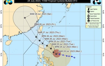
Perez said Egay, last tracked 525 km. east of Baler, Aurora, is forecast to remain as a typhoon until Tuesday.
TCWS no. 2 has been hoisted over Catanduanes, central and eastern portion of Isabela (Palanan, Dinapigue, Santo Tomas, Cabagan, Tumauini, San Pablo, Maconacon, Santa Maria, Quezon, Delfin Albano, Mallig, Quirino, Roxas, Burgos, Ilagan City, Divilacan, San Mariano, Gamu, Naguilian, Benito Soliven, City of Cauayan, Reina Mercedes, Luna, San Manuel, Aurora, Cabatuan, San Guillermo, Echague, Jones, Angadanan, Alicia, San Mateo, San Isidro, San Agustin), eastern portion of Albay (Rapu-Rapu, Bacacay, City of Tabaco, Malilipot, Malinao, Tiwi), eastern portion of Camarines Sur (Caramoan, Presentacion, Garchitorena, Lagonoy, San Jose, Sagñay), northern portion of Aurora (Dilasag, Casiguran, Dinalungan), eastern portion of Quirino (Maddela), eastern and central portion of Cagayan (Santa Ana, Gonzaga, Lal-Lo, Santa Teresita, Buguey, Gattaran, Baggao, Peñablanca, Amulung, Alcala, Iguig, Tuguegarao City, Solana, Enrile), and the northern portion of Camarines Norte (Calaguas and Maculabo Islands), and the northeastern portion of Northern Samar (Laoang, Palapag).
Minor to moderate impacts from gale-force winds are possible in these areas.
On the other hand, minimal to minor impacts from strong winds are forecast in areas under TCWS no. 1: Sorsogon, the rest of Albay, the rest of Camarines Sur, the rest of Camarines Norte, the rest of Isabela, the rest of Cagayan including Babuyan Islands, Apayao, Abra, Kalinga, Mountain Province, Ifugao, the rest of Quirino, Nueva Vizcaya, Batanes, Masbate including Ticao Island, Burias Island, Quezon including Pollilo Islands, the rest of Aurora, Benguet, Ilocos Sur, Ilocos Norte, La Union, Nueva Ecija, Pangasinan, Tarlac, Zambales, Bulacan, Pampanga, Bataan, Marinduque, Cavite, Metro Manila, Rizal, Laguna, eastern and central portion of Romblon (Banton, Corcuera, Romblon, Magdiwang, Cajidiocan, San Fernando) and the northern and central portion of Batangas (Calaca, Cuenca, Taysan, Lian, Tuy, Balayan, Talisay, Padre Garcia, Agoncillo, Santo Tomas, San Jose, Lemery, Lipa City, Ibaan, City of Tanauan, Mataasnakahoy, Alitagtag, Balete, Nasugbu, San Juan, San Nicolas, Rosario, Laurel, Santa Teresita, Taal, Malvar), Eastern Samar, the rest of Northern Samar, Samar, Biliran, northern and central portion of Leyte (Tunga, Pastrana, San Miguel, Mahaplag, Matag-Ob, Tolosa, Palo, Calubian, Leyte, Mayorga, Julita, Carigara, Babatngon, Dagami, Jaro, Abuyog, San Isidro, Santa Fe, Albuera, Villaba, La Paz, Palompon, Macarthur, Tabontabon, Tanauan, Merida, Ormoc City, Isabel, Javier, Dulag, Capoocan, Alangalang, City of Baybay, Burauen, Tabango, Tacloban City, Kananga, Barugo) and the northern portion of Cebu (Daanbantayan, Medellin) including Bantayan Islands, Camotes Islands.
Egay and the enhanced southwest monsoon may also cause gusty conditions over the rest of the Visayas and Mimaropa, and the northern portions of Zamboanga Peninsula, Northern Mindanao, and Caraga.
PAGASA, meanwhile, said there is minimal to moderate risk of storm surge which may cause flooding in the low-lying and exposed coastal areas of Batanes, Cagayan, Ilocos Norte, and Isabela.
The coastal waters along the northern and eastern seaboards of Northern Luzon, the eastern seaboard of Central Luzon, the seaboards of Southeastern Luzon, and the eastern seaboards of the Visayas and Northeastern Mindanao are still risky for small seacrafts.
PAGASA is still expecting Egay to cross the Luzon Strait and make landfall or pass very close to the Babuyan Islands-Batanes area between Tuesday night and Wednesday afternoon.
"We are also not ruling out the possibility that Egay may reach the super typhoon category by Wednesday," said Perez.
He also warned that residents of Isabela, Batanes, Cagayan and Babuyan Group of Islands must prepare for Egay's possible landfall.
The bureau forecasts for the typhoon to exit the Philippine Area of Responsibility on Thursday. (PNA)
