(Grabbed from PAGASA's Facebook page)
MANILA – Super Typhoon Egay has maintained its strength and is still forecast to make landfall or pass very close to Babuyan Islands-northeastern mainland Cagayan area between late Tuesday and Wednesday.
Egay packs maximum sustained winds of 185 kph near the center and gustiness of up to 230 kph. It was last tracked 190 km. east of Aparri, Cagayan.
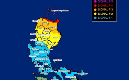
In its 5 p.m. bulletin, the Philippine Atmospheric, Geophysical and Astronomical Services Administration (PAGASA) said signal no. 5 remains hoisted over the eastern portion of Babuyan Islands (Camiguin Island). Very strong winds of more than 185 kph may be expected
Signal no. 4 has been hoisted over the northern portion of Cagayan (Santa Ana, Gonzaga, Claveria, Sanchez-Mira, Pamplona, Abulug, Ballesteros, Aparri, Buguey, Santa Teresita, Camalaniugan, Santa Praxedes) and the rest of Babuyan Islands. Significant to severe impacts from typhoon-force winds may be experienced in these areas.
The northeastern portion of Isabela (Divilacan, Maconacon, Palanan, Santa Maria, San Pablo, Santo Tomas, Cabagan, Tumauini), the rest of Cagayan, Apayao, Ilocos Norte, the northern portion of Kalinga (Rizal, Pinukpuk, Balbalan), Batanes and the northern portion of Abra (Tineg, Lagayan, Lacub, Danglas) were placed under signal no. 3 and they may experience moderate to significant impacts from storm-force winds.
Signal no. 2 is still hoisted over rest of Isabela, northern and central portions of Aurora (Dilasag, Casiguran, Dinalungan, Dipaculao), Quirino, the rest of Kalinga, northeastern portion of Nueva Vizcaya (Kasibu, Quezon, Diadi, Bagabag, Ambaguio, Villaverde, Solano, Bayombong), Ilocos Sur, the rest of Abra, Mountain Province, Ifugao, northern portion of Benguet (Bakun, Mankayan, Buguias, Kabayan, Kibungan, Atok) and northern portion of La Union (Bangar, Sudipen, Luna, Balaoan, Santol). These areas will continue to experience minor to moderate impacts from gale-force winds.
Signal no. 1 remains hoisted over Quezon including Polillo Islands, the rest of Aurora, the rest of Nueva Vizcaya, the rest of Benguet, the rest of La Union, Nueva Ecija, Pangasinan, Tarlac, Zambales, Bulacan, Pampanga, Bataan, Cavite, Metro Manila, Rizal, Laguna, Batangas, Camarines Norte, Camarines Sur, Catanduanes and Marinduque. Minimal to minor impacts from strong winds are still likely in these areas.
Other areas in Luzon, the Visayas, Zamboanga Peninsula, Basilan, Sulu, Tawi-Tawi, and the northern portions of Northern Mindanao and Caraga that are not under any wind signal will continue to bring gusty conditions due to Egay and the enhanced southwest monsoon.
Meanwhile, PAGASA said Egay is nearing its peak intensity, and is forecast to exit the Philippine Area of Responsibility on Thursday. (PNA)
