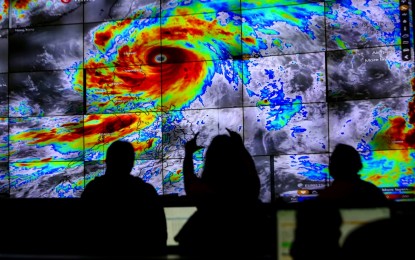
TYPHOON MONITORING. Atmospheric scientists of the weather bureau PAGASA monitor the track of Typhoon Egay, in their headquarters in Quezon City on Tuesday (July 25, 2023). Many areas in Luzon will continue to experience strong winds due to the typhoon. (PNA photo by Joan Bondoc)
MANILA – Many areas in Luzon will continue to experience strong winds as Typhoon Egay wobbles the coastal waters near Fuga Island in Aparri, Cagayan.
The Philippine Atmospheric, Geophysical and Astronomical Services Administration (PAGASA) reported that the typhoon made landfall in Aparri at 3:10 a.m. Wednesday.
In its 8 a.m. bulletin, the weather bureau said the typhoon packs maximum sustained winds of 175 kph near the center and gustiness of up to 240 kph.
"Violent, life-threatening conditions are expected to continue over Babuyan Islands, the northwestern portion of mainland Cagayan, and the northern portions of Apayao and Ilocos Norte in the next 6 hours," said PAGASA.
Significant to severe impacts from typhoon-force winds may prevail over areas where Tropical Cyclone Wind Signal (TCWS) No. 4 has been hoisted: the northern portion of Cagayan (Santa Ana, Gonzaga, Claveria, Sanchez-Mira, Pamplona, Abulug, Ballesteros, Aparri, Buguey, Santa Teresita, Camalaniugan, Santa Praxedes) including Babuyan Islands, the northern portion of Apayao (Calanasan, Luna, Santa Marcela), and the northern portion of Ilocos Norte (Burgos, Bangui, Dumalneg, Pagudpud, Adams, Pasuquin, Vintar, Bacarra).
Moderate to significant impacts from storm-force winds may be experienced in areas under Signal No. 3: Batanes, the rest of Cagayan, the rest of Apayao, the northern portion of Kalinga (Rizal, Pinukpuk, Balbalan), the northern portion of Abra (Tineg, Lagayan, Lacub, Danglas, Bangued, La Paz, San Juan, Dolores, Tayum, Lagangilang, Malibcong, Licuan-Baay, Peñarrubia, Pidigan, Langiden, San Quintin, Bucay, San Isidro, Sallapadan), the rest of Ilocos Norte, and the northern portion of Ilocos Sur (Magsingal, San Juan, Cabugao, Sinait, San Vicente, Santo Domingo, San Ildefonso, Bantay, Santa Catalina, City of Vigan, Caoayan, Santa, Nagbukel, Narvacan).
Minor to moderate impacts from gale-force winds, on the other hand, are likely in areas where Signal No. 2 has been hoisted: Isabela, the rest of Kalinga, Mountain Province, Ifugao, Benguet, the rest of Abra, the rest of Ilocos Sur, La Union, and the northern and western portions of Pangasinan (Sison, San Jacinto, Pozorrubio, San Fabian, Dagupan City, Calasiao, Binmaley, Lingayen, Bugallon, Mabini, Labrador, Infanta, Dasol, Burgos, Agno, City of Alaminos, Sual, Anda, Bolinao, Bani, San Manuel, Binalonan, Laoac, Manaoag, Mangaldan, Mapandan, Santa Barbara, San Nicolas).
Areas under Signal No. 1 -- Aurora, Quirino, Nueva Vizcaya, the rest of Pangasinan, Nueva Ecija, Tarlac, Pampanga, Bulacan, Zambales, Bataan, Metro Manila, Rizal, Cavite, Laguna, the northern portion of Batangas (Talisay, City of Tanauan, Santo Tomas, Balete, Malvar, Lipa City), the northern and central portion of Quezon (Pitogo, Calauag, Infanta, Lopez, Guinayangan, Unisan, Plaridel, Quezon, Alabat, Padre Burgos, Mauban, General Nakar, Perez, Agdangan, Gumaca, Atimonan, Real, Tagkawayan, Lucena City, Pagbilao, Lucban, Sampaloc, City of Tayabas, Dolores, Sariaya, Candelaria, Tiaong, San Antonio) including Polillo Islands, Camarines Norte, the northern portion of Camarines Sur (Siruma, Tinambac, Goa, Lagonoy, Caramoan, Cabusao, Sipocot, Garchitorena, Ragay, Del Gallego, Calabanga, Presentacion, Lupi), and the northern portion of Catanduanes (Pandan, Bagamanoc, Panganiban, Viga, Caramoran) -- may experience minimal to minor impacts from strong winds.
Gusty conditions due to Egay and the southwest monsoon will also prevail over Luzon and the Visayas.
Both Egay and the southwest monsoon will also cause rough to very high seas over several coastal waters along the seaboards of Luzon and the Visayas. Sea travel is risky for most vessels, and all mariners are advised to remain in port or seek safe harbor until winds and waves subside.
Egay is forecast to exit the Philippine Area of Responsibility on Thursday, PAGASA said. (PNA)
