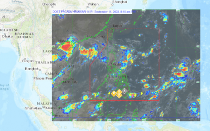
(Screenshot from PAGASA website)
MANILA – The two low-pressure areas (LPAs) that the weather bureau has been monitoring have a slim chance of developing into a tropical cyclone.
One LPA was last located 875 km. east-northeast of extreme Northern Luzon, inside the Philippine Area of Responsibility (PAR).
Another LPA was last tracked 1,960 km. east-northeast of Eastern Visayas outside the PAR.
"The LPA outside PAR enhances the southwest monsoon (habagat) that affects Mindanao. So we are expecting high chances of rains, particularly in Zamboanga Peninsula," Obet Badrina of the Philippine Atmospheric, Geophysical and Astronomical Services Administration (PAGASA) said.
PAGASA forecast cloudy skies with scattered rain showers and thunderstorms to prevail over the Zamboanga Peninsula.
Flash floods or landslides are likely due to moderate to at times heavy rains, it said.
The trough of the LPA inside the PAR, meanwhile, will also cause scattered rain showers and thunderstorms over Batanes and Babuyan Islands.
Moderate to heavy rains are also possible and could result in flash floods and landslides.
The rest of the country will continue to experience isolated rain showers caused by localized thunderstorms.
Light to moderate winds and slight to moderate seas will prevail over the entire archipelago, PAGASA said. (PNA)
