(Grabbed from PAGASA's Facebook page)
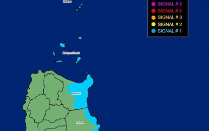
MANILA – Severe Tropical Storm Jenny has intensified into a typhoon before dawn on Monday prompting the weather bureau to raise Tropical Cyclone Wind signal no. 1 over several areas in Northern Luzon.
Batanes, Babuyan Islands, the eastern portion of mainland Cagayan (Santa Ana, Gonzaga, Buguey, Santa Teresita, Lal-Lo, Baggao, Gattaran, Peñablanca), and the eastern portion of Isabela (Maconacon, Divilacan, Palanan) will experience strong winds that may cause minimal to minor impacts, the Philippine Atmospheric, Geophysical and Astronomical Services Administration (PAGASA) warned.
Jenny also enhances the southwest monsoon, causing gusty conditions over most of Mimaropa, Western Visayas, and the Bicol Region.
The typhoon packs maximum sustained winds of 120 kph near the center, and gustiness of up to 150 kph. It was last tracked 655 km. east of Aparri, Cagayan or 665 km. east of Calayan, Cagayan.
PAGASA forecast Jenny to reach its peak intensity on Tuesday and possibly make landfall over the southern portion of Taiwan on Thursday afternoon or evening.
"A landfall or close approach scenario over the Batanes area is still not ruled out, although the likelihood is decreasing," PAGASA said.
Meanwhile, Jenny will cause moderate to rough seas over the coastal waters of mainland Cagayan.
PAGASA advised mariners of motor bancas and similarly-sized vessels to take precautionary measures while venturing to the sea and, or avoid navigating in these conditions. (PNA)
