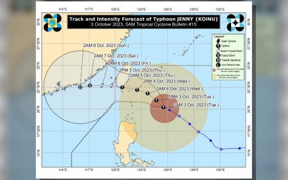
RAINY TUESDAY. Track of Typhoon Jenny as of Tuesday (Oct. 3, 2023) morning. The weather bureau has raised Tropical Cyclone Wind Signal No. 2 over Batanes as Jenny maintained its strength, packing maximum sustained winds of 165 kilometers per hour near the center and gustiness of up to 205 kph. (PAGASA image)
MANILA – Tropical Cyclone Wind Signal No. 2 has been hoisted over Batanes as Typhoon Jenny maintained its strength, packing maximum sustained winds of 165 kilometers per hour near the center and gustiness of up to 205 kph, the weather bureau said Tuesday.
In its 4 a.m. weather advisory, the Philippine Atmospheric, Geophysical and Astronomical Services Administration (PAGASA) said gale-force winds could cause minor to moderate impact in affected areas.
Minimal to minor impacts from strong winds are possible in areas under Signal No. 1: Cagayan including Babuyan Islands, the northern and eastern portions of Isabela (Maconacon, Divilacan, Palanan, Santa Maria, San Pablo, Tumauini, Cabagan, Ilagan City, San Mariano, Santo Tomas, Dinapigue, Benito Soliven, Naguilian, Gamu, Quirino, Delfin Albano, Quezon, Mallig), Apayao, the northeastern portion of Abra (Tineg, Lacub, Malibcong), the northern portion of Kalinga (Balbalan, Pinukpuk, Rizal, City of Tabuk) and Ilocos Norte.
Jenny, last located 350 km east of Basco, Batanes, is forecast to enhance the southwest monsoon or "habagat", causing occasional rains over the western portions of Central and Southern Luzon and the Visayas in the next three days.
The enhanced southwest monsoon will also cause gusty conditions over Aurora, Bataan, Bulacan, Metro Manila, Region 4-A (Calabarzon), Bicol Region and most of Mimaropa and Western Visayas in the next three days.
Meanwhile, the typhoon will cause rough to very rough seas over the northern and eastern seaboards of Northern Luzon. "Sea travel is risky for vessels of any type or tonnage. All mariners must remain in port or, if underway, seek shelter or safe harbor as soon as possible," PAGASA said.
Moderate to rough seas will prevail over the coastal waters of northern Aurora.
PAGASA advised operators of motor bancas and similarly-sized vessels to take precautionary measures while venturing into the sea. (PNA)
