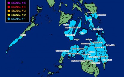
(Image courtesy of PAGASA)
MANILA – Tropical cyclone wind signal no. 1 is still hoisted over a number of areas across the country as “Kabayan” weakened into tropical depression.
In its 11 a.m. bulletin, the weather bureau said Kabayan has made landfall over Manay, Davao Oriental, and has been almost stationary.
Kabayan was last tracked in the vicinity of Caraga, Davao Oriental, and packing maximum sustained winds of 55 kph near the center and gustiness of up to 70 kph.
The southern portion of Palawan (Sofronio Española, Brooke's Point, Bataraza, Balabac, Rizal, Quezon, Narra) including Cagayancillo Islands, Southern Leyte, the southern portion of Samar (Basey, Santa Rita, Marabut, Talalora, Villareal, Pinabacdao), the southern portion of Eastern Samar (Maydolong, City of Borongan, Quinapondan, Guiuan, Lawaan, Balangiga, Llorente, Giporlos, Salcedo, Balangkayan, General Macarthur, Hernani, Mercedes), Cebu including Camotes Islands, Bantayan Islands, Bohol, Siquijor, Negros Oriental, Negros Occidental and Guimaras, are still under Signal No. 1.
Also under Signal No. 1 are the southern portion of Palawan (Sofronio Española, Brooke's Point, Bataraza, Balabac, Rizal, Quezon, Narra) including Cagayancillo Islands Southern Leyte, Leyte, the southern portion of Samar (Basey, Santa Rita, Marabut, Talalora, Villareal, Pinabacdao), the southern portion of Eastern Samar (Maydolong, City of Borongan, Quinapondan, Guiuan, Lawaan, Balangiga, Llorente, Giporlos, Salcedo, Balangkayan, General Macarthur, Hernani, Mercedes), Cebu including Camotes Islands, Bantayan Islands, Bohol, Siquijor, Negros Oriental, Negros Occidental and Guimaras Misamis Oriental, Camiguin, Bukidnon, Davao de Oro, the northern portion of Davao Oriental (Baganga, Manay, Caraga, Tarragona, Lupon, Banaybanay, Boston, Cateel), Misamis Occidental, Lanao del Norte, Lanao del Sur, Davao del Norte, Davao City, the northern portion of Cotabato (Arakan, Carmen, Banisilan, Alamada, President Roxas, Kabacan, Matalam, Antipas, Magpet, Libungan, Pigkawayan), the northern portion of Maguindanao (Buldon, Barira, Matanog, Parang, Sultan Kudarat, Sultan Mastura), the western and central portion of Zamboanga del Norte (Siayan, Sindangan, Jose Dalman, Manukan, Pres. Manuel A. Roxas, Sergio Osmeña Sr., Katipunan, Dipolog City, Polanco, Mutia, Piñan, Dapitan City, Sibutad, La Libertad, Rizal, Siocon, Baliguian, Gutalac, Labason, Kalawit, Tampilisan, Liloy, Salug, Godod, Bacungan), the western and central portion of Zamboanga del Sur (Midsalip, Labangan, Tukuran, Aurora, Sominot, Ramon Magsaysay, Tambulig, Dumingag, Mahayag, Josefina, Molave, Vincenzo A. Sagun, Guipos, Dimataling, Dumalinao, Lakewood, Dinas, San Pablo, Tigbao, Tabina, Kumalarang, Lapuyan, Pitogo, Margosatubig, San Miguel, Bayog, Pagadian City), Zamboanga Sibugay, Dinagat Islands, Surigao del Norte, Agusan del Norte, Surigao del Sur and Agusan del Sur.
Strong winds will prevail in those areas, the Philippine Atmospheric, Geophysical and Astronomical Services Administration (PAGASA) said.
Meanwhile, Kabayan could affect the shear line, which could cause heavy rainfall over the eastern portion of Southern Luzon.
Due to the northeast monsoon and Kabayan, sea travel for small seacraft remains risky over the coastal waters along the seaboard of Northern Luzon, the eastern and central seaboards of the Visayas, and the eastern seaboards of Central and Southern Luzon, and Mindanao.
Kabayan is forecast to emerge over the Sulu Sea between Monday afternoon or evening, PAGASA said. (PNA)
