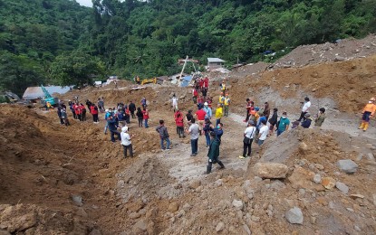
GROUND ZERO. The landslide-stricken area in Barangay Masara Maco, Davao de Oro province where rescue operations continue after the incident on Feb. 6, 2024. The University of the Philippines Resilience Institute bared on Wednesday (Feb. 14) that the country’s hazard maps must be updated to improve disaster preparedness especially in vulnerable areas. (PNA file photo by Robinson Niñal Jr.)
MANILA – The country’s hazard maps must be updated to ensure improved disaster preparedness especially in vulnerable areas, the University of the Philippines Resilience Institute (UPRI) bared on Wednesday.
In a Bagong Pilipinas Ngayon interview, UPRI Director Mahar Lagmay cited that the available hazard map in 2013 underestimated the storm surges of Yolanda.
“Kumbaga iyong ating hazard map ay sinabi na kakapiranggot lamang ang pagpasok noong storm surge sa kalupaan, pero imbes na 20 meters lang or 30 meters from the coast, ay pumasok ito ng mahigit isang kilometro, maaaring dalawang kilometro (The hazard map said only a small storm surge will hit the land, but instead of 20 to 30 meters from the coast, it was over one kilometer, about two kilometers),” Lagmay said.
He said the country’s ability to anticipate the storm surge could be “lacking as Yolanda may have been a climate change impact”.
The country needs to prepare hazard maps with climate change scenarios and scenarios of hazards that are bigger than the nation’s past experiences, he said.
“Sa ngayon, noong tiningnan ko iyong mapa ng Yolanda sa Tacloban ay pareho pa rin ang mapa ng ibinigay bago humagupit ang Yolanda sa Tacloban, so kailangan po nating palitan iyan (Now, when I looked at the map of Yolanda in Tacloban, it’s the same with the map given before Yolanda hit Tacloban, so it must be changed). Improve so that we can have better anticipatory actions,” he added.
Currently, he said a flood forecasting system is in place. It is used by local government units nationwide to warn residents of areas at risk about possible floods.
He also said the safest places to be during natural disaster are listed in noah.up.edu.ph website.
While landslides cannot be identified by these systems, Lagmay said they can identify triggers that cause landslides in specific areas.
The UPRI is in the process of improving government efforts and facilitating talks for massive education campaign to help all Filipinos become aware of disaster risk reduction and management.
Citizen scientists
Lagmay also underscored the need for citizen scientists in collection of pertinent date since the Philippines is prone to natural disasters.
He noted that climate change scientists and disaster practitioners met in Sendai, Japan and agreed that a “whole-of-society and science-based approach” is crucial in disaster preparedness.
Citing that Filipinos are affected by hazard impacts, he said it is important for them to be engaged in projects related to science.
“Kapag na-engage sila ay maaaring ma-inspire sila, at kapag na-inspire sila at na-engage ay lumalawak po iyong tinatawag na ownership to the problem (When they’re engaged, they will be inspired, they in turn will have ownership to the problem),” he said.
Ownership to the problem would lead to broader disaster awareness which is the first step to combatting impacts of flood, landslides, and earthquakes among others, he added. (PNA)
