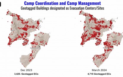
GEO-TAGGED. The geo-tagged evacuation sites and centers in Western Visayas as of March 2024. In a report by the response committee during the Regional Disaster Risk Reduction and Management Council (RDDRRM) full council meeting on Friday (March 15, 2024), 4,715 buildings in Western Visayas were geo-tagged this month. (screenshot from the virtual meeting)
ILOILO CITY – Agencies under the response committee of the Regional Disaster Risk Reduction and Management Council (RDDRRM) have released PHP16.28 million in relief assistance to victims of various disasters that happened in Western Visayas this first quarter of 2024.
In a report during the RDRRMC first quarter full council meeting held virtually on Friday, the Department of Social Welfare and Development (DSWD) provided the highest assistance amounting to PHP11.74 million, local government units shared PHP2.83 million, and from other sources at PHP1.71 million.
“The first quarter of the year recorded 164 incidents, which is three times higher than the first quarter last year that we have recorded,” the DSWD said.
Of the 164 incidents, fire topped the list with 154; armed conflict has four; two incidents of monsoon rains; and one each for El Niño, soil erosion, thunderstorms, and others affecting 20,542 individuals.
Most of the affected families were victims of incidents of fire, armed conflict, El Niño and monsoon rains.
Meantime, the camp coordination and camp management cluster has geo-tagged 4,715 buildings designated as evacuation sites and centers as of this month.
Data showed that 40.6 percent of those geo-tagged were schools, 21.7 percent were barangay halls, 8.8 percent covered courts, and 8 percent were government buildings.
Others included health centers, chapel/church, gymnasium, purpose-built evacuation center, private buildings, and open spaces.
“They are scheduled to roam around Iloilo City and Capiz next week to follow up on geo-tagging,” the DSWD said.
The camp coordination and camp management also admitted having challenges in geo-tagging of evacuation sites and centers in the northern portion of Negros Occidental, the fourth and fifth districts of Iloilo, and parts of Antique. (PNA)
