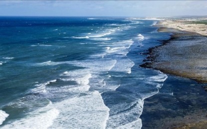
GLOBAL WARMING. Experts said ocean temperatures posted new dangerous levels and this is expected to result in extreme weather conditions. Average sea surface temperature reached a new high of 21.09 degrees Celsius in end-February 2024 and experts traced this to the impact of El Niño over the Pacific Ocean last year. (Anadolu)
ISTANBUL – As ocean temperatures hit new dangerous peaks, experts are warning the unprecedented levels of accumulated heat will trigger intense chain reactions, including deadly hurricanes and cyclones, over the coming months.
Recent reports have shown that oceans worldwide are now at their warmest ever.
The European Union’s Copernicus Climate Change Service found that sea surface temperatures were exceptionally high through most of 2023 and the beginning of 2024.
At the end of February 2024, the daily average sea surface temperature reached a new absolute high of 21.09 degrees Celsius (69.962 degrees Fahrenheit).
Climate researcher Leon Simons told Anadolu that the emergence of an El Niño over the Pacific Ocean last year led to increased warming of oceans and the atmosphere, triggering changes in weather patterns.
“With the whole of the Atlantic Ocean record warm, that will increase temperatures, especially this year in the coming months … With these higher temperatures, hurricanes can get stronger … (and) you can have very heavy flooding like we saw in Libya, Greece and in many parts of the world last year,” he said.
The flooding, he explained, is because of increased rainfall, which happens when warm air cools down as it moves over land or especially elevated areas such as mountains.
Another climate researcher, Joel Hirschi, said temperatures in the Atlantic are “exceptionally high.”
“If these temperatures persist later into the year, past May-June into July into the hurricane season, that could favor a very active hurricane season, especially in conjunction with the El Niño that is waning,” he said.
Why are the world’s oceans getting warmer?
The unprecedented warming of oceans is a combination of greenhouse emissions, as well as a strong El Nino event that started last year and is still ongoing, said Hirschi, associate head of marine systems modeling at the UK’s National Oceanography Center.
The anomalously warm temperatures also have to do with atmospheric circulation, which is conducive to the development of “marine heat waves,” he said.
For Simons, a key factor apart from greenhouse emissions is the reduction in sulfur emissions, especially from shipping and coal-fired power plants.
“When we reduce air pollution, more sunlight can reach the oceans. The oceans are warming much faster, especially where this air pollution has been reduced in areas where a lot of shipping was happening,” said Simons, a climate researcher at the Club of Rome Netherlands.
He said the International Maritime Organization introduced in 2020 new regulation to reduce by 80 percent the amount of sulfur in fuels used for shipping.
“Because there’s now much less sulfur being emitted, much less sunlight is being reflected by this air pollution to space,” he said, adding that this change has been visibly proven with NASA satellite data.
El Niño-La Niña transition and extreme weather
About the projections for coming months, Hirschi said the weakening El Niño will very likely switch to a La Niña.
El Niño and La Niña are both climate phenomena that originate in the Pacific Ocean but can affect weather worldwide.
An El Niño is when warm water builds up and pushes sea surface temperatures above average, while La Niña is the complete opposite, when cool water increases and drags down temperatures to below the average level.
They are two distinct phases of what is known as the El Niño-Southern Oscillation, or ENSO, and can never occur at the same time.
“It is known that La Niña additionally favors conditions that are conducive for the formation of tropical cyclones over the North Atlantic,” said Hirschi.
The areas likely to be impacted are Central American countries such as Belize, Honduras, and Mexico, along with the US, including southern areas like Florida, but also much of the East Coast, he said.
It could also go all the way to Canada and sometimes even curve back toward Europe, he added.
Hirschi said precursor signs of a La Niña event are building up in the Pacific.
“La Niña anomaly phases are when you tend to have droughts over South America and it gets wetter over Australia. So, La Niña years are favorable for torrential rainfall over Australia and in the regions in the Western Pacific,” he said.
A sort of positive effect of La Niña could be that ocean temperatures are expected to fall back a bit below the levels of 2023, he added.
Apart from hurricanes and cyclones, both scientists warned there will be more extreme weather events in the coming months.
One of them will be heat waves, which Hirschi pointed out are now more frequent and intense, with heat records being regularly shattered and not by “a few tenths of a degree but sometimes three, four or even five degrees.”
Simons called for steps to “prepare ourselves for a lot of extreme weather in the months ahead.”
“We should prepare ourselves for a lot of unpredictable extreme weather because we are now in a situation where our planet hasn’t been for millions of years, with greenhouse gas concentration now higher than it has (ever) been,” he said.
Eyes on the Mediterranean
Both Hirschi and Simons pointed out that the Mediterranean is another region that is warmer than usual at the moment.
The Mediterranean had massive heat waves last year, said Hirschi, adding that there have also been “severe marine heat waves” recorded in the region “for more than 10 years in a row.”
There are higher chances of “medicanes,” he said, referring to a destructive weather phenomenon that scientists have previously warned will increase due to global warming.
The term is a combination of the words Mediterranean and hurricane.
“They’re tropical cyclones, like a hurricane, like storms, that develop over the Mediterranean and … can pick moisture and the heat of these warm ocean temperatures,” Hirschi explained.
An example was Storm Daniel last year, which severely affected countries like Bulgaria, Greece, and especially Libya with tragic consequences, he said.
The reason for the warmer Mediterranean over the past few years is the “excursion of very warm air from Africa, pushing towards Europe, engulfing the Mediterranean” and forming so-called heat domes that then stayed for a long time, he explained.
Simons said the Mediterranean is also seeing the effects of rules enforced to control sulfur emissions.
By May 2025, they will further reduce these sulfur emissions which will cause even more warming, he said.
“We see that much more sunlight is being absorbed in this region now that this regulation has come into effect. We should expect that to increase further when the regulation is strengthened in May next year. Then, of course, the damages will keep increasing faster,” he warned.
Concern is now obviously much higher
Francesca Guglielmo, a senior scientist at the Copernicus Climate Change Service, told Anadolu that the recent trend “in terms of global surface air and sea surface temperature is unprecedented.”
“Both in terms of deviation from the climate normal and duration. The concern is now obviously much higher than, for example, a year ago,” she said.
Simons also emphasized the danger of the current situation, pointing out that it takes 3,000 times more heat to warm the oceans than the same amount of air.
“So, that’s why it’s very concerning that … the temperatures are so much higher than they were ever before,” he said.
Hirschi said the crisis should not come as a surprise to anyone, but should be taken as yet another wake-up call.
“This is what we expect with global warming. This is what global warming looks like,” he said. (Anadolu)
