MANILA – Tropical Depression Aghon has intensified into a tropical storm over Tayabas Bay, the Philippine Atmospheric, Geophysical and Astronomical Services Administration (PAGASA) reported on Sunday.
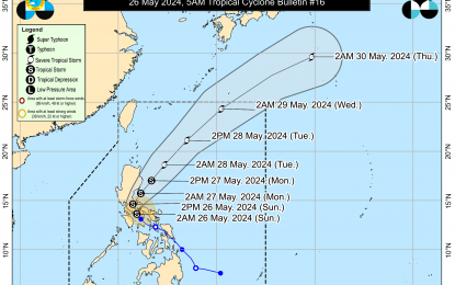
Based on its 5 a.m. bulletin, the weather bureau said the center of Aghon was estimated over the coastal waters of Lucena City, Quezon province with a maximum sustained wins of 65 kilometers per hour near the center and gustiness of up to 90km/h.
It is moving northwestward at 10 km/h and is forecast to make landfall in the vicinity of Quezon within the next three hours.
Tropical Cyclone Wind Signal (TCWS) No. 2 is now hoisted over the northern and central portions of Quezon (Alabat, Perez, Quezon, Gumaca, Lopez, Macalelon, General Luna, Unisan, Pitogo, Plaridel, Agdangan, Padre Burgos, Atimonan, Mauban, Real, General Nakar, Infanta, Sampaloc, Pagbilao, Calauag, Lucban, City of Tayabas, Lucena City, including Polillo Islands.
Areas under TCWS No. 1 include the southeastern portion of Isabela (Palanan, Dinapigue), the southern portion of Quirino (Maddela, Nagtipunan), the southern portion of Nueva Vizcaya (Alfonso Castaneda), the eastern and southern portions of Nueva Ecija (General Tinio, Gabaldon, Bongabon, Pantabangan, Rizal, General Mamerto Natividad, Laur, Palayan City, Peñaranda, San Leonardo, City of Gapan, Cabanatuan City, Santa Rosa, San Isidro, Cabiao, San Antonio, Jaen), Aurora, the eastern portion of Pampanga (Candaba, San Luis, San Simon, Apalit, Santa Ana, Arayat), Bulacan, Metro Manila, the rest of Quezon, Rizal, Laguna, Cavite, Batangas, the northern portion of Oriental Mindoro (Pinamalayan, Pola, Naujan, Victoria, Socorro, City of Calapan, Bansud, Gloria, Baco, San Teodoro, Puerto Galera, Bongabong, Roxas), Marinduque, Romblon, Camarines Norte, Camarines Sur, the northern portion of Albay (Tiwi, Polangui, Malinao, Libon, Oas, City of Ligao), and Burias Island.
The weather bureau said minor to moderate impacts from strong winds are possible within any of the localities where Wind Signal No. 2 is hoisted.
It added that sea travel is risky for small seacrafts particularly over the coastal waters of Marinduque and Quezon, the southern coastal waters of Batangas, and the northern coastal waters of Camarines Norte where a gale warning is hoisted.
Over the next 12 hours, the tropical storm will cross the landmass of mainland Calabarzon (Cavite, Laguna, Batangas, Rizal and Quezon) and Polillo Islands.
“Aghon will be over the waters off the east coast of Quezon or Aurora by this evening or early Monday morning. During this period, AGHON will likely remain as a tropical storm although weakening into a tropical depression while over mainland Calabarzon is not ruled out due to land interaction,” the weather bureau said.
From Monday through the remainder of the forecast period, Aghon will gradually accelerate northeastward while intensifying.
“It is forecast to reach severe tropical storm category on Tuesday. Aghon reaching typhoon category within the Philippine Area of Responsibility (PAR) is not yet ruled out, although it will most likely happen far from the landmass,” PAGASA said.
The tropical storm may exit the PAR region on Wednesday.
Meanwhile, PAGASA said the forecast accumulated rainfall is expected to reach between 100 to 200 mm in Quezon, Aurora, the eastern portion of Bulacan, Rizal, Laguna, Metro Manila, and Camarines Norte.
It added the forecast rainfall are generally higher in elevated or mountainous areas.
“Under these conditions, flooding and rain-induced landslides are likely especially in areas that are highly or very highly susceptible to these hazards as identified in hazard maps and in localities that experienced considerable amounts of rainfall for the past several days,” it added. (Lloyd Caliwan/PNA)
