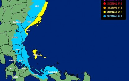
Areas under Tropical Cyclone Wind Signal No. 2 and No. 1 due to Typhoon Aghon (Image from PAGASA Facebook)
MANILA – Tropical Cyclone Wind Signal (TCWS) No. 2 is hoisted in several areas in Luzon Monday as Typhoon Aghon slightly intensified, packing maximum sustained winds of 140 kph near the center and gusts of up to 170 kph, the weather bureau said.
In its 8 a.m. bulletin, the Philippine Atmospheric, Geophysical and Astronomical Services Administration (PAGASA) said gale-force winds may be experienced in areas under TCWS No. 2 such as the southeastern portion of Isabela (Dinapigue, Palanan), the northern portion of Aurora (Baler, Dipaculao, Dinalungan, Dilasag, Casiguran), and Polillo Islands.
The typhoon was last tracked over the coastal waters of Casiguran, Aurora, moving north northeast at 10 kph.
It is forecast to exit the Philippine Area of Responsibility on Wednesday.
Strong winds will prevail in the following areas under TCWS No. 1:
northeastern and southern portion of Isabela (Divilacan, San Mariano, San Guillermo, Jones, Echague, San Agustin, Ilagan City, Benito Soliven, City of Cauayan, Maconacon, Angadanan, Naguilian), the eastern portion of Quirino (Maddela, Nagtipunan, Aglipay), the eastern portion of Nueva Vizcaya (Alfonso Castaneda, Dupax del Sur, Dupax del Norte), the rest of Aurora, eastern portion of Nueva Ecija (General Tinio, Gabaldon, Bongabon, Pantabangan, Rizal, General Mamerto Natividad, Laur, Palayan City, Peñaranda, San Leonardo, City of Gapan, Cabanatuan City, Santa Rosa, Llanera), the eastern portion of Bulacan (San Miguel, San Ildefonso, Doña Remedios Trinidad, Norzagaray), Rizal, the northeastern portion of Laguna (Pakil, Mabitac, Pangil, Famy, Siniloan, Santa Maria, Paete, Kalayaan, Lumban), the northern and central portions of Quezon (General Nakar, Infanta, Real, Mauban, Perez, Alabat, Quezon, Calauag, Tagkawayan, Guinayangan, Lopez, Atimonan, Gumaca, Plaridel), and the western portion of Camarines Norte (Santa Elena, Vinzons, Labo, Capalonga, Paracale, Talisay, Jose Panganiban, San Vicente, Daet) including Calaguas Islands.
PAGASA said there is a minimal to moderate risk of storm surge over the exposed and low-lying coastal areas of Cagayan, Isabela, Aurora, and Polillo Islands within the next 24 hours.
A gale warning is hoisted over the coastal waters of Cagayan (southern portion), Isabela, Aurora, and the northern coastal waters of Quezon including Polillo Islands.
Sea travel is risky for small seacraft, including all motorbancas.
Aghon will also bring moderate to rough seas over the eastern coastal waters of Cagayan and the northern coastal waters of Bicol Region.
Mariners of motor bancas and similarly-sized vessels are advised to take precautionary measures.
Meanwhile, at least six domestic flights were canceled due to Aghon -- CebGo DG 6031/6032 Manila-San Jose-Manila; DG 6113/6114 and DG 6117/6118 Manila-Naga-Manila. (PNA)
