MANILA -- Tropical Depression Domeng is forecast to bring rains to the southern part of the country, the state weather bureau said Tuesday.
In its 4 p.m. weather bulletin, the Philippine Atmospheric, Geophysical and Astronomical Services Administration (PAGASA) said the Bicol region, Visayas, northern Mindanao, Caraga, Davao region, Soccsksargen, Maguindanao and Lanao del Sur will have cloudy skies with moderate to occasionally heavy rains; and thunderstorms due to the tropical depression until Wednesday afternoon.
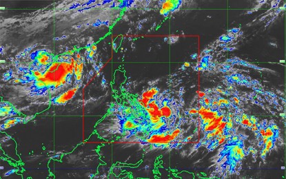
“Domeng” was last spotted 690 km. east of Guiuan, Eastern Samar, packing winds of 45 km. per hour (km/h) near the center, and gustiness of up to 60 km/h. It will move north-northwest at 14 km/h.
PAGASA warned of possible flooding or landslides due to moderate to occasional heavy rains in these areas.
Another low-pressure area (LPA), meanwhile, was spotted 1,030 km. east of Virac, Catanduanes, along the intertropical convergence zone (ITCZ), which is a known breeding ground for typhoons.
Metro Manila and other areas will also experience partly cloudy to cloudy skies with isolated rain showers due to local thunderstorms.
The western section of Luzon and Palawan will have moderate to rough coastal waters due to moderate to strong winds blowing from the southwest to south.
Other parts of Luzon will have moderate to rough coastal waters caused by moderate to strong winds from the northeast to north.
Visayas and Mindanao, however, will have moderate to occasionally rough coastal waters, pushed by moderate to occasionally strong winds blowing from the northwest to west.
On Tuesday, PAGASA recorded a minimum temperature of 27.4°C and a peak temperature of 34.2°C.
The country is expected to have a temperature range of 16-36°C until Saturday. (PNA)
