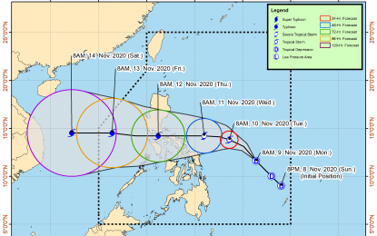
(Image grabbed from PAGASA's website)
MANILA – Tropical Depression (TD) Ulysses slightly accelerated and may possibly reach the tropical storm category within 24 hours, the weather bureau said on Monday.
In its 11 a.m. bulletin, the Philippine Atmospheric, Geophysical and Astronomical Services Administration (PAGASA) said "Ulysses" was last seen 635 kilometers (km) east northeast of Surigao City, Surigao del Norte, or 605 km east of Borongan City, Eastern Samar.
"Ulysses" packs maximum sustained winds of 55 kilometers per hour (kph) near the center and gustiness of up to 70 kph. It is moving northwest at 40 kph.
No tropical cyclone wind signal has been hoisted yet on any part of the country, as "Ulysses" is not directly causing severe weather, according to PAGASA.
It is forecast to head towards the Bicol Region-Quezon area, and may further intensify into a typhoon before making landfall on Wednesday.
Meanwhile, the tail-end of a cold front affecting extreme Northern Luzon will cause moderate to heavy rains with at times intense rains over Cagayan, including the Babuyan Islands, Isabela, and Aurora.
Flooding and rain-induced landslides may occur in highly susceptible areas during heavy or prolonged rainfall.
Moderate to rough seas may be experienced over the eastern seaboards of the country in the next 24 hours, PAGASA said.
It added that mariners of small seacraft are advised to take precautionary measures when venturing to the sea. (PNA)
