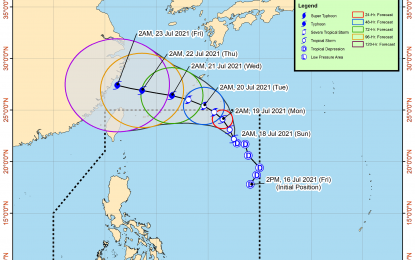
Tropical Storm “Fabian” track (DOST/PAGASA)
MANILA – Tropical cyclone “Fabian” has intensified into a tropical storm but is unlikely to bring heavy rainfall in the country in the next 24 hours, the Philippine Atmospheric, Geophysical and Astronomical Services Administration (PAGASA) said on Sunday.
As of 4 a.m., the center of Tropical Storm (TS) Fabian was estimated at 1,090 kilometers (km) east northeast of extreme Northern Luzon, the PAGASA said in its 5 a.m. weather bulletin.
“Fabian” has maximum sustained winds of 65 km per hour near the center and gustiness of up to 80 kph as it moves north-northwestward at 10 kph.
The weather bureau said no tropical cyclone wind signal is currently in effect but “Fabian” and another low pressure area outside the Philippine area of responsibility (PAR) estimated at 630 km west of Calayan, Cagayan are currently enhancing the southwest monsoon.
Western Visayas, Palawan, and Occidental Mindoro will experience rains due to the southwest monsoon in the next 24 hours, it added.
Metro Manila, the Ilocos Region, rest of Mimaropa, Bicol, rest of the Visayas, the Zamboanga Peninsula, Zambales, Bataan, Cavite, Batangas, Laguna, Tawi-Tawi, Sulu and Basilan will have cloudy skies with scattered rain showers and thunderstorms.
The rest of the country will experience partly cloudy to cloudy skies with rain showers or thunderstorms.
The PAGASA said “Fabian” intensified into a tropical storm at 2 a.m. Sunday and expected to reach severe tropical storm category by Monday afternoon.
“It is likely to reach typhoon category by Tuesday evening and reach a peak intensity of 140 kph before making landfall over mainland China,” it added.
In the next 24 hours, the waters in affected areas may be risky particularly to small sea vessels.
The tropical storm is forecast to exit the PAR Monday evening. (PNA)
