(Grabbed from PAGASA's Facebook page)
MANILA -- Weather disturbance "Domeng" has intensified into a tropical storm, now packing maximum sustained winds of 65 kph near the center, and gustiness of up to 80 kph.
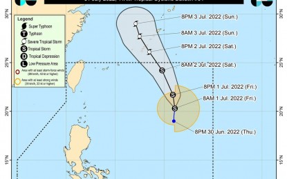
In its 11 a.m. bulletin, the weather bureau said Domeng was last tracked 940 kilometers east of extreme northern Luzon, moving northward 15 kph.
The Philippine Atmospheric, Geophysical and Astronomical Services Administration (PAGASA) forecast Domeng to remain far from the landmass, and exit the Philippine Area of Responsibility on Saturday.
Meanwhile, Domeng and Severe Tropical Storm Chaba (formerly Caloy) continue to enhance the southwest monsoon, which will cause monsoon rains over Kalayaan Islands. This will also bring light to moderate rains over Pangasinan, Zambales, Bataan, Occidental Mindoro, and the rest of Palawan.
Flooding and rain-induced landslides are likely in those areas, especially those that are highly susceptible to hazards.
The enhanced southwest monsoon will bring occasional gusty conditions reaching strong breeze to near gale in strength over extreme northern Luzon, the northern and western portions of Luzon, and the western portion of the Visayas. These conditions are more likely in coastal and mountainous or upland localities.
Rough to very rough seas will be experienced over the western seaboards of central and southern luzon (Zambales, Bataan, The Western Coast Of Occidental Mindoro Including Lubang Island, And The Western Coast Of Palawan Including Kalayaan Island); western seaboard of northern luzon (Ilocos Sur, La Union, And Pangasinan).
Moderate to rough seas continue to prevail over the remaining seaboards of northern Luzon. These conditions may be risky for small seacraft.
PAGASA advised mariners to take precautionary measures when venturing to the sea. If possible, avoid navigating in these conditions. (PNA)
