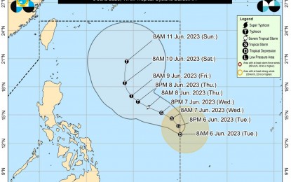
Track of Tropical Depression Chedeng (Courtesy of PAGASA)
MANILA – The low pressure area inside the Philippine Area of Responsibility has developed into Tropical Depression (TD) Chedeng, the weather bureau said Tuesday.
Chedeng packs maximum sustained winds of 45 kph near the center and gustiness of up to 55 kph.
It was last tracked 1,170 km east of southeastern Luzon, the Philippine Atmospheric, Geophysical and Astronomical Services Administration (PAGASA) said in an 11:30 a.m. update.
Chedeng is almost stationary and is forecast to remain far from the landmass, unlikely to directly bring heavy rainfall over any part of the country in the next three to five days.
PAGASA, however, does not rule out the possibility that Chedeng may enhance the southwest monsoon (habagat).
The bureau noted that the areas, timing and intensity of monsoon rains may still change as the enhancement would depend on the movement and intensity of the TD.
"The potential for occasional wind gusts due to the enhanced monsoon winds may still change," PAGASA added.
The TD is also unlikely to cause rough sea condition over the coastal waters of the country in the next 24 hours.
Meanwhile, Chedeng may intensify into a tropical storm on Wednesday, and reach the typhoon category on Thursday, PAGASA said. (PNA)
