(Grabbed from PAGASA Facebook page)
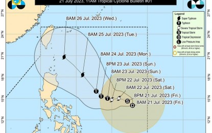
MANILA – The weather bureau reported that the low pressure area (LPA) last found east of southeastern Luzon developed into a tropical depression (TD) and was named Egay on Friday.
Packing maximum sustained winds of 55 kph near the center and gustiness of up to 70 kph, Egay was last tracked 900 km. east of southeastern Luzon and slowly moving north-northwestward, according to the 11 a.m. bulletin released by the Philippine Atmospheric, Geophysical and Astronomical Services Administration (PAGASA).
Currently, no tropical cyclone wind signal is hoisted on any part of the country as the TD does not have a direct effect on the weather yet.
PAGASA, however, forecast Egay to enhance the southwest monsoon, which could cause strong breeze to near gale conditions with intermittent gusts beginning on Saturday over Mimaropa, Western Visayas, and the western portion of Mindanao.
Monsoon rains are also possible over the western sections of Mimaropa and the Visayas on Sunday.
Egay could also intensify into a tropical storm in the next 12 hours and could continue to intensify and reach the super typhoon category by late Monday or early Tuesday as it moves over the Philippine Sea.
Egay is also expected to cause moderate to rough seas over the eastern seaboards of Southern Luzon and Eastern Visayas on Sunday.
Mariners of small seacrafts are advised to take precautionary measures when venturing to the sea, and to avoid navigating in these conditions if possible, PAGASA said. (PNA)
