(PNA photo by Yancy Lim)
MANILA – The center of Tropical Storm (TS) Egay was estimated based on all available data at 605 km east northeast of Virac, Catanduanes or at 725 km east of Daet, Camarines Norte, according to the 5 a.m. advisory of state weather bureau Philippine Atmospheric, Geophysical and Astronomical Services Administration.
No Tropical Cyclone Wind Signal is raised as of posting time but in anticipation of the arrival of strong breeze to near-gale conditions, wind signals may be hoisted in some areas in Bicol Region and Eastern Visayas within the day.
Current forecast scenario shows that the highest wind signal that may be hoisted will be Wind Signal No. 3 or 4, potentially over extreme Northern Luzon.
However, should a southward shift in the track occur, higher wind signals may be hoisted.
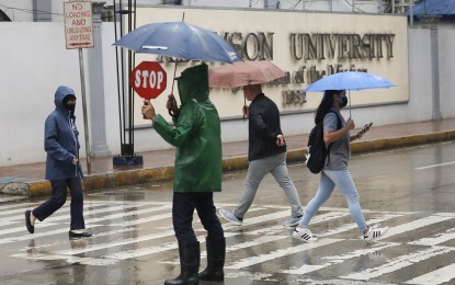
TS Egay may also enhance the southwest monsoon (habagat), bringing occasional rains over several areas of the country in the next three days.
It is forecast to reach typhoon category within 24 hours and may become a super typhoon on Tuesday.
Although the latest track forecast shows that Egay will remain offshore for most of the forecast period, a close approach or landfall in the vicinity of extreme Northern Luzon is still not ruled out based on the forecast confidence cone.
On the track forecast, Egay will be closest to extreme Northern Luzon on Wednesday.
A slight weakening trend may begin on Wednesday and will continue until Egay makes landfall over Taiwan.
Interaction with the mountainous terrain of Taiwan will result in further weakening, a trend which will continue until the tropical cyclone makes another landfall on mainland China.
Meanwhile, the Coast Guard Station in Surigao del Norte (CGS-SDN) suspended Sunday morning sea travels within its area of jurisdiction because of the continued weather disturbance affecting the province.
In an advisory, the CGS-SDN ordered the suspension of travel of vessels and watercraft with 250 gross tonnages due to the strong to gale force winds associated with TS Egay.
The suspension of travel covers the routes to Dinagat Islands, Siargao Island, and Bucas Grande Island.
“The strong to gale force winds, associated with the southwest monsoon, is affecting the eastern coasts of Mindanao resulting in rough and very rough sea conditions with a wave height of 2.8 to 4.5 meters,” Jose Julis Fajardo, acting station commander of CGS-SDN said.
The travel will resume as soon as the weather and sea conditions improve, he said.
The CGS-SDN also reported on Sunday that it rescued 11 passengers of a submerged boat off the waters of Barangay Day-asan, Surigao City Saturday.
The agency said it received a distress call from a concerned citizen that a motor banca ran aground in the area of Day-asan after leaving a floating resort and on its way to Surigao City proper.
A team was immediately dispatched to rescue the boat passengers.
Eastern Visayas will have cloudy skies with scattered rainshowers and thunderstorms due to the trough of Egay.
The rest of Visayas, Palawan including Kalayaan Islands, and Occidental Mindoro will have cloudy skies with scattered rainshowers and thunderstorms due to the southwest monsoon.
Metro Manila and the rest of the country will have partly cloudy to cloudy skies with isolated rainshowers or thunderstorms.
Sunset is at 6:28 p.m. (With reports from Alexander Lopez, PNA)
