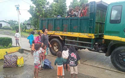
RESCUE. The Cagayan Provincial Disaster Risk Reduction and Management Office reports the evacuation of 17 families, composed of 57 persons, in Gonzaga town at around 5 p.m. on Saturday (Aug. 26, 2023) because of flooding caused by Typhoon Goring. Some towns are also experiencing power interruption as the municipality and six others are under Tropical Cyclone Wind Signal No. 2. (Courtesy of MDRRMO-Gonzaga)
MANILA – Typhoon Goring has intensified as it moved south southwestward over the sea east of Babuyan Islands, according to the 5 p.m. weather bulletin of the Philippine Atmospheric, Geophysical and Astronomical Services Administration (PAGASA).
The center of the eye of Goring was estimated based on all available data, including those from the Aparri Weather Radar, at 155 km east of Aparri, Cagayan as of posting time.
It may reach “super typhoon” category on Monday, according to PAGASA.
Tropical Cyclone Wind Signal (TCWS) No. 3 is up over the northeastern portion of Cagayan (Santa Ana) and the extreme eastern portion of Isabela (Divilacan, Palanan); No. 2 over the eastern portion of Isabela (Dinapigue, San Mariano, Ilagan City, Maconacon, Cabagan, Tumauini, San Pablo), eastern portion of Cagayan (Peñablanca, Baggao, Gattaran, Lal-Lo, Gonzaga, Santa Teresita, Buguey) and the northern portion of Aurora (Dilasag, Casiguran); and No. 1 over Batanes, the rest of Cagayan including Babuyan Islands, central portion of Aurora (Dinalungan, Dipaculao), Quirino, the rest of Isabela, Apayao, eastern portion of Nueva Vizcaya (Kasibu, Quezon, Diadi, Bagabag, Solano, Villaverde), eastern portion of Ifugao (Lamut, Lagawe, Hingyon, Banaue, Mayoyao, Aguinaldo, Alfonso Lista), eastern portion of Mountain Province (Barlig, Natonin, Paracelis) and Kalinga.
Ruelie Rapsing, Cagayan provincial disaster risk reduction management officer, said in an online news briefing Saturday that coast guards, police and village watchmen are guarding coastal areas to ensure no violations of the "no sailing, no fishing, no swimming" policy.
Prepositioning of stockpiles of relief goods have been readied even at the community level, Rapsing said.
In Batanes province, disaster risk reduction management officer Roldan Esdicul said relief goods are prepositioned in typhoon-prone towns and even in the island towns of Itbayat and Sabtang.
A pre-disaster risk assessment was already done, he added.
Goring is forecast to move generally southward to southwestward until Sunday, then will turn generally eastward to northeastward.
Afterwards, the typhoon will exit its looping path and move northwestward on Tuesday towards the sea east of Taiwan while moving on a consistent pace.
The enhanced southwest monsoon will also continue to bring gusty conditions over areas not under any TCWS on Monday, especially in coastal and upland/mountainous areas exposed to winds. (With a report from Villamor Visaya Jr./PNA)
