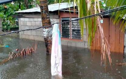
HELP NEEDED. Zones 4 and 6 in Barangay Minanga, Aparri, Cagayan are flooded due to heavy rains brought by Super Typhoon Goring on Sunday (Aug. 27, 2023). The Municipal Disaster Risk Reduction and Management Office-Aparri said the knee-deep flood started around midnight and is affecting 118 families composed of 383 persons. (Courtesy of MDRRMO-Aparri)
MANILA – Goring has reached super typhoon category and was spotted based on all available data, including those from Baler and Daet Weather Radars, at 95 km east northeast of Casiguran, Aurora as of the 11 a.m. weather bulletin Sunday.
Tropical Cyclone Wind Signal (TCWS) No. 3 is up over the eastern portion of Isabela (Divilacan, Palanan, Dinapigue, Ilagan City, San Mariano).
TCWS No. 2 is hoisted over the eastern portion of mainland Cagayan (Peñablanca, Baggao, Gattaran, Lal-Lo, Gonzaga, Santa Teresita, Buguey, Santa Ana, Enrile, Tuguegarao City), the northern and central portion of Isabela (Maconacon, Cabagan, Tumauini, San Pablo, Benito Soliven, San Guillermo, Jones, Echague, San Agustin, Angadanan, City of Cauayan, Naguilian, Gamu, Santa Maria, Santo Tomas, Delfin Albano, Quirino, Burgos, Reina Mercedes, Alicia, Luna, Quezon, Mallig, Roxas, San Manuel, Aurora, Cabatuan, San Mateo, San Isidro), the extreme northern portion of Aurora (Casiguran, Dinalungan, Dilasag), and the eastern portion of Quirino (Maddela).
Under TCWS No. 1 are Batanes, the rest of Cagayan including Babuyan Islands, the rest of Aurora, the rest of Quirino, the rest of Isabela, Apayao, Nueva Vizcaya, Ifugao, Mountain Province, Kalinga, Abra, eastern portion of Ilocos Norte (Pagudpud, Adams, Vintar, Carasi, Nueva Era, Banna, Marcos, Dingras, Solsona, Piddig, Dumalneg, Bangui), Pollilo Islands, eastern portion of Benguet (Bokod, Buguias, Kabayan, Mankayan), eastern portion of Nueva Ecija (Carranglan, Pantabangan, Bongabon, Gabaldon, Laur, Rizal), and Calaguas Islands.
Goring is forecast to begin its loop over the Philippine Sea east of Cagayan-Isabela area Sunday, according to the Philippine Atmospheric, Geophysical and Astronomical Services Administration.
The super typhoon will then turn northeastward and northward tomorrow before shifting northwestward on Tuesday.
On the track forecast, it will make landfall over the southern portion of Taiwan on Wednesday evening or on Thursday early morning.
Goring is forecast to remain at super typhoon category until it makes landfall over southern Taiwan.
Land interaction with Taiwan’s rugged terrain will weaken the super typhoon.
It is likely that Goring will emerge over the Taiwan Strait and exit the Philippine Area of Responsibility region on Friday as a severe tropical storm or a typhoon in its lowest limit. (PNA)
