(Photo courtesy of PAGASA website)
MANILA --Typhoon "Liwayway" will have no direct effect over any part of the country but it enhances the southwest monsoon that affects northern Luzon, a weather specialist said on Wednesday.
Philippine Atmospheric, Geophysical and Astronomical Services Administration (PAGASA) weather specialist Ana Clauren said the southwest monsoon causes scattered rain showers over parts of Ilocos Region, Cordillera Administrative Region and Cagayan Valley.
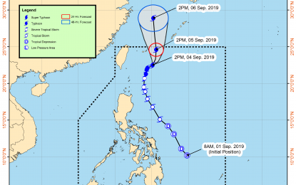
Liwayway was last seen at 420 km. northeast of Basco, Batanes, heading northeast at 10 kph. The typhoon has a maximum sustained winds of 140 kph near the center, and gustiness of up to 170 kph.
Clauren said PAGASA is expecting Liwayway to be outside the Philippine Area of Responsibility by Thursday afternoon or in the evening.
However, there is a low-pressure area (LPA) eyed at 860 km. east northeast of Hinatuan, Surigao del Sur.
"It is possible that this LPA would develop into a typhoon in the next 48 hours. If this happens, the next typhoon would be named 'Marilyn'," Clauren said.
Meanwhile, according to PAGASA, the rest of the country will experience isolated rain showers caused by localized thunderstorms.
Strong winds will blow over northern Luzon and the western part of central Luzon. Coastal waters along these areas will be rough.
Over Visayas and the rest of Luzon, winds will be moderate to strong with moderate to rough seas.
Light to moderate winds will prevail over Mindanao with slight to moderate seas, PAGASA said. (PNA)
Philippine Atmospheric, Geophysical and Astronomical Services Administration (PAGASA) weather specialist Ana Clauren said the southwest monsoon causes scattered rain showers over parts of Ilocos Region, Cordillera Administrative Region and Cagayan Valley.
Liwayway was last seen at 420 km. northeast of Basco, Batanes, heading northeast at 10 kph. The typhoon has a maximum sustained winds of 140 kph near the center, and gustiness of up to 170 kph.
Clauren said PAGASA is expecting Liwayway to be outside the Philippine Area of Responsibility by Thursday afternoon or in the evening.
However, there is a low-pressure area (LPA) eyed at 860 km. east northeast of Hinatuan, Surigao del Sur.
"It is possible that this LPA would develop into a typhoon in the next 48 hours. If this happens, the next typhoon would be named 'Marilyn'," Clauren said.
Meanwhile, according to PAGASA, the rest of the country will experience isolated rain showers caused by localized thunderstorms.
Strong winds will blow over northern Luzon and the western part of central Luzon. Coastal waters along these areas will be rough.
Over Visayas and the rest of Luzon, winds will be moderate to strong with moderate to rough seas.
Light to moderate winds will prevail over Mindanao with slight to moderate seas, PAGASA said. (PNA)
