(Photo courtesy of PAGASA)
MANILA – Tropical Storm Nanmadol (international name) is likely to enter the country and enhance the southwest monsoon or “habagat” this week, the weather bureau said Wednesday.
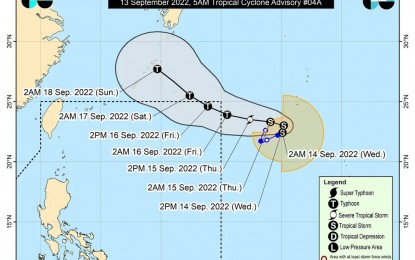
"Nanmadol" was last tracked at 1,910 km. east of extreme northern Luzon and could enter the Philippine Area of Responsibility (PAR) either on Thursday night or early Friday.
"Once it enters PAR, it could intensify and reach the typhoon category. It is forecast to remain far from the landmass, and will not have a direct effect on any part of the country," forecaster Grace Castañeda of the Philippine Atmospheric, Geophysical and Astronomical Services Administration (PAGASA) said in its 5 a.m. weather bulletin.
The weather disturbance, to be given the local name "Josie", however, will enhance the southwest monsoon that will cause rains, especially over the western section of Southern Luzon and the Visayas.
Meanwhile, the southwest monsoon is forecast to cause scattered rain showers and thunderstorms over the provinces of Occidental Mindoro, Palawan, Aklan, and Antique on Wednesday.
Flash floods or landslides are possible due to moderate to at times heavy rains.
The rest of the country will experience isolated rain showers caused by localized thunderstorms.
Moderate to strong winds and moderate to rough seas will prevail over extreme Northern Luzon.
Fishing boats and other small vessels are alerted against moderate to rough seas over the northern seaboard of Northern Luzon (Batanes and the Babuyan Islands).
Elsewhere, winds will be light to moderate with slight to moderate seas. (PNA)
